Waterfall Canyon Trail
excerpted from our book
Salt Lake City's Incredible Hiking and Biking Trails
pages 285-287
|
Buy book directly from the author!
Salt Lake City's Incredible Hiking and Biking Trails
- has access info for 73 trailheads
- 73 colorful trail maps
- 325 full color photographs
- loads of hiking tips
|
regularly $19.95
now on sale for only
$9.95
click here
for book orders
|


This hike is very popular among Ogden’s teenagers, and on a summer day you are likely to see dozens of young people making their
way up the trail to the foot of the waterfall. The last half of the Waterfall
Canyon Trail is very steep and rocky, and if you are hiking in the spring or early summer you
may get your feet wet climbing up through the drainage. But the walk is short, and the added adventure just seems to make the hike all the more appealing.
The creek above Waterfall Canyon is only two miles long, and after mid-June, when all the snow in Malans Basin has melted, the volume of water coming over the
fall is greatly diminished. It is best to do the hike during the spring runoff in May or early June when the waterfall is most impressive. But the creek
never dries up completely, and even in late summer you will find at least some water coming down the rock face.
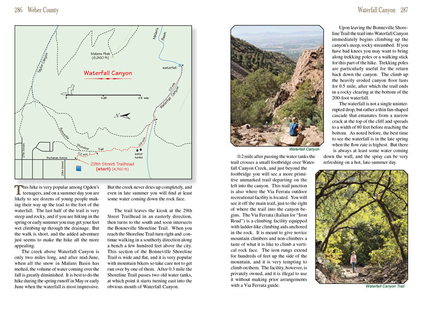
The Waterfall Canyon Trail leaves the kiosk at the 29th Street Trailhead in an easterly direction, then turns to the south and soon intersects the Bonneville Shoreline Trail.
When you reach the Shoreline Trail turn right and continue walking in a southerly direction along a bench a few hundred feet above the city. This section
of the Bonneville Shoreline Trail is wide and flat, and it is very popular with mountain bikers so take care not to get run over by one of them. After 0.3
mile the Shoreline Trail passes two old water tanks, at which point it starts turning east into the obvious mouth of Waterfall Canyon.
0.2 mile after passing the water tanks the
Waterfall Canyon Trail crosses a small footbridge over Waterfall Canyon Creek, and just beyond the footbridge you will see a more
primitive unmarked trail departing on the left into the canyon. This trail junction is also where the Via Ferrata outdoor recreational facility is located.
You will see it off the main trail, just to the right of where the trail into the canyon begins. The Via Ferrata (Italian for “Iron Road”) is a climbing
facility equipped with ladder-like climbing aids anchored in the rock. It is meant to give novice mountain climbers and non-climbers a taste of what it
is like to climb a vertical rock face. The iron rungs extend for hundreds of feet up the side of the mountain, and it is very tempting to climb on them.
The facility, however, is privately owned, and it is illegal to use it without making prior arrangements with a Via Ferrata guide.
Upon leaving the Bonneville Shoreline Trail the trail into Waterfall Canyon immediately begins climbing up the canyon’s steep, rocky streambed. If you have
bad knees you may want to bring along trekking poles or a walking stick for this part of the hike. Trekking poles are particularly useful for the return back
down the canyon. The climb up the heavily eroded canyon floor lasts for 0.5 mile, after which the trail ends in a rocky clearing at the bottom of the
200-foot waterfall.
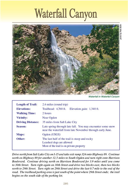
The waterfall is not a single uninterrupted drop, but rather a thin fan-shaped cascade that emanates from a narrow crack at the top of the cliff and spreads
to a width of 80 feet before reaching the bottom. As noted before, the best time to see the waterfall is in the late spring when the flow rate is highest.
But there is always at least some water coming down the wall, and the spray can be very refreshing on a hot, late-summer day.
Note to web developers: You may copy this material onto your site, but in return please include a link to my home page
www.utahtrails.com. Thank you, David Day (utahdavidday at gmail.com)
Click here to see more
trails near Salt Lake City
© Rincon Publishing Company, all rights reserved
|

