Silver & Silver Glance Lake
excerpted from our book
Salt Lake City's Incredible Hiking and Biking Trails
pages 175-179
|
Buy book directly from the author!
Salt Lake City's Incredible Hiking and Biking Trails
- has access info for 73 trailheads
- 73 colorful trail maps
- 325 full color photographs
- loads of hiking tips
|
regularly $19.95
now on sale for only
$9.95
click here
for book orders
|


 Before starting this hike you might want to pause for a few minutes to enjoy the spectacular scenery at Silver Lake Flat. Silver Lake Flat Reservoir
is surrounded by a mixture of conifers and quaking aspen with the Wasatch peaks rising prominently on all sides. The trailhead is located on the
northern shore of the reservoir, and the view to the south includes a marvelous panorama of Mount Timpanogos and the adjacent peaks. Silver Lake
Flat is a popular destination for fishermen, and the reservoir is stalked with rainbow trout throughout the summer, but, unfortunately, overnight
camping is not permitted within a half mile of the water. The nearest campground is at Granite Flat, three miles below the reservoir.
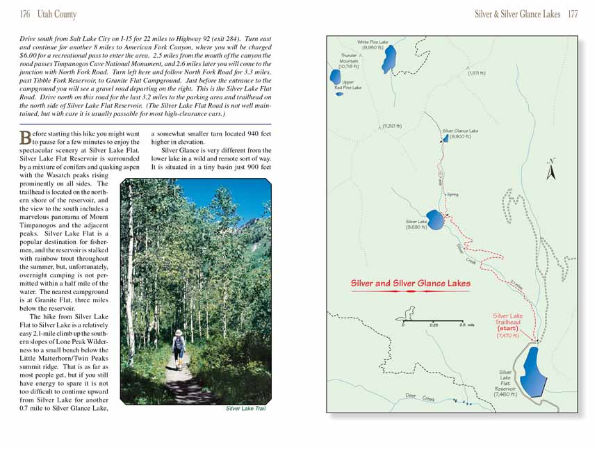
The hike from Silver Lake Flat to Silver Lake is a relatively easy 2.1-mile climb up the southern slopes of Lone Peak Wilderness to a small bench
below the Little Matterhorn/Twin Peaks summit ridge. That is as far as most people get, but if you still have energy to spare it is not too difficult
to continue upward from Silver Lake for another 0.7 mile to Silver Glance Lake, a somewhat smaller tarn located 940 feet higher in elevation.
Silver Glance Lake is very different from the lower
Silver Lake in a wild and remote sort of way. It is situated in a tiny basin just 900 feet below the summit
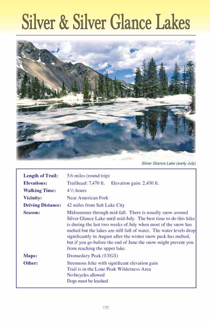
ridge, and the setting is pristine. Although the lake is on the south-facing side of the ridge it is usually at least partially frozen and surrounded
by snow well into July. Occasionally an adventurous hiker will continue beyond Silver Glance
Lake, scrambling the last 760 feet to a low point on the ridge
to peer down into Little Cottonwood Canyon on the north side of the wilderness area. The reward is an unforgettable view of White Pine Lake, 0.5 mile
north and 680 feet below the saddle.
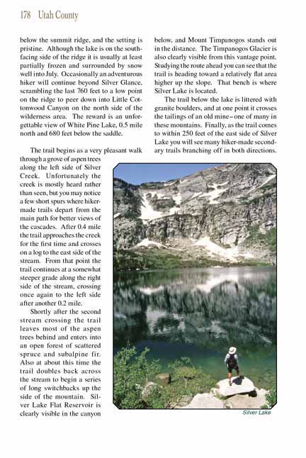
The trail begins as a very pleasant walk through a grove of aspen trees along the left side of Silver Creek. Unfortunately the creek is mostly heard
rather than seen, but you may notice a few short spurs where hiker-made trails depart from the main path for better views of the cascades. After 0.4
mile the Silver Lake trail approaches the creek for the first time and crosses on a log to the east side of the stream. From that point the trail continues at a
somewhat steeper grade along the right side of the stream, crossing once again to the left side after another 0.2 mile.
 Shortly after the second stream crossing the Silver Lake trail leaves most of the aspen trees behind and enters into an open forest of scattered spruce and
subalpine fir. Also at about this time the trail doubles back across the stream to begin a series of long switchbacks up the side of the mountain.
Silver Lake Flat Reservoir is clearly visible in the canyon below, and Mount Timpanogos stands out in the distance. The Timpanogos Glacier is also
clearly visible from this vantage point. Studying the route ahead you can see that the trail is heading toward a relatively flat area higher up the
slope. That bench is where Silver Lake is located.
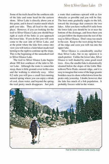
The trail below the lake is littered with granite boulders, and at one point it crosses the tailings of an old mine-one of many in these mountains.
Finally, as the trail comes to within 250 feet of the east side of Silver Lake you will see many hiker-made secondary trails branching off in both
directions. Some of the trails head for the southern side of the lake and some head for the eastern shore. Silver Lake is directly above you at this
point, and it doesn’t matter much which path you take. They all lead to the same place. However, if you are looking for the trail to Silver Glance
Lake you should bear right at each of the forks as you approach the lower lake. If you do this you will soon come to the east side of Silver Lake,
and at the point where the lake first comes into view you will notice a faint hiker-made trail turning to the right to continue up the slope. This
is the beginning of the unmarked trail to Silver Glance Lake.
The trail to Silver Glance Lake begins about 300 feet southeast of the inlet to Silver Lake. Although the route is somewhat steep, there is little
ground cover in this area and the walking is relatively easy. After 0.2 mile you will pass a small fast-running natural spring where you can enjoy
a drink of cool, clean water, and beyond the spring the trail pretty much disappears. Just pick a route that continues upward with as few obstacles
as possible and you will be fine. The best route gradually angles to the left, toward the drainage that connects the two lakes. After you have
walked 0.4 mile from the lower lake you should be in or near the bottom of the drainage, and from there you can just follow the depression the rest
of the way to Silver Glance Lake. Don’t stray too much to the east. Keep to the west along the base of the ridge and soon you will run into the upper lake.
Silver Glance Lake is considerably smaller than Silver Lake, but in my opinion it is much prettier. Unlike the lower lake, Silver Glance
Lake is well shaded
by some good sized trees. Also, the smaller lake is dramatically situated below the slopes of the Little Matterhorn/Twin Peaks summit ridge, and it
is easy to imagine that some of the huge granite boulders near its shore rolled down from the peaks only yesterday. I doubt, however, that the lake
has much of a fish population. It probably freezes solid in the winter.
Note to web developers: You may copy this material onto your site, but in return please include a link to my home page
www.utahtrails.com. Thank you, David Day (utahdavidday at gmail.com)
Click here to see more
trails near Salt Lake City
© Rincon Publishing Company, all rights reserved
|


 Before starting this hike you might want to pause for a few minutes to enjoy the spectacular scenery at Silver Lake Flat. Silver Lake Flat Reservoir
is surrounded by a mixture of conifers and quaking aspen with the Wasatch peaks rising prominently on all sides. The trailhead is located on the
northern shore of the reservoir, and the view to the south includes a marvelous panorama of Mount Timpanogos and the adjacent peaks. Silver Lake
Flat is a popular destination for fishermen, and the reservoir is stalked with rainbow trout throughout the summer, but, unfortunately, overnight
camping is not permitted within a half mile of the water. The nearest campground is at Granite Flat, three miles below the reservoir.
 Shortly after the second stream crossing the Silver Lake trail leaves most of the aspen trees behind and enters into an open forest of scattered spruce and
subalpine fir. Also at about this time the trail doubles back across the stream to begin a series of long switchbacks up the side of the mountain.
Silver Lake Flat Reservoir is clearly visible in the canyon below, and Mount Timpanogos stands out in the distance. The Timpanogos Glacier is also
clearly visible from this vantage point. Studying the route ahead you can see that the trail is heading toward a relatively flat area higher up the
slope. That bench is where Silver Lake is located.