Indian Trail
excerpted from our book
Salt Lake City's Incredible Hiking and Biking Trails
pages 292-295
|
Buy book directly from the author!
Salt Lake City's Incredible Hiking and Biking Trails
- has access info for 73 trailheads
- 73 colorful trail maps
- 325 full color photographs
- loads of hiking tips
|
regularly $19.95
now on sale for only
$9.95
click here
for book orders
|
 Ogden Canyon was once an important transit route for Indians and trappers traveling from Ogden Valley to the eastern shore of the Great
Salt Lake. Ogden Valley, located about seven miles east of the present day city of Ogden, was an immensely fertile area filled with wetlands and wild game. A
British party, led by Peter Skene Ogden, recorded in 1825 that they had trapped 563 beaver in the valley in a period of just six days. Frequent flooding along
the Ogden River, however, often made travel in and out of the valley difficult, and for that reason the early Indians established an alternate route that bypasses
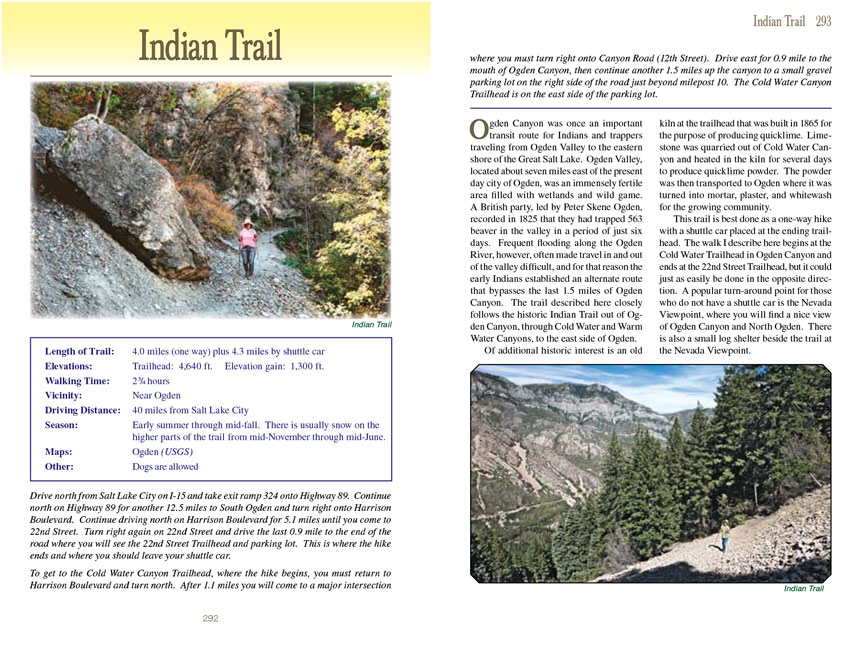
the last 1.5 miles of Ogden Canyon. The trail described here closely follows the historic Indian Trail out of Ogden Canyon, through Cold Water and Warm Water
Canyons, to the east side of Ogden.
Ogden Canyon was once an important transit route for Indians and trappers traveling from Ogden Valley to the eastern shore of the Great
Salt Lake. Ogden Valley, located about seven miles east of the present day city of Ogden, was an immensely fertile area filled with wetlands and wild game. A
British party, led by Peter Skene Ogden, recorded in 1825 that they had trapped 563 beaver in the valley in a period of just six days. Frequent flooding along
the Ogden River, however, often made travel in and out of the valley difficult, and for that reason the early Indians established an alternate route that bypasses
the last 1.5 miles of Ogden Canyon. The trail described here closely follows the historic Indian Trail out of Ogden Canyon, through Cold Water and Warm Water
Canyons, to the east side of Ogden.
Of additional historic interest is an old kiln at the trailhead that was built in 1865 for the purpose of producing quicklime. Limestone was quarried out of Cold
Water Canyon and heated in the kiln for several days to produce quicklime powder. The powder was then transported to Ogden where it was turned into mortar, plaster,
and whitewash for the growing community.
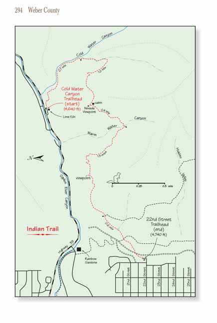
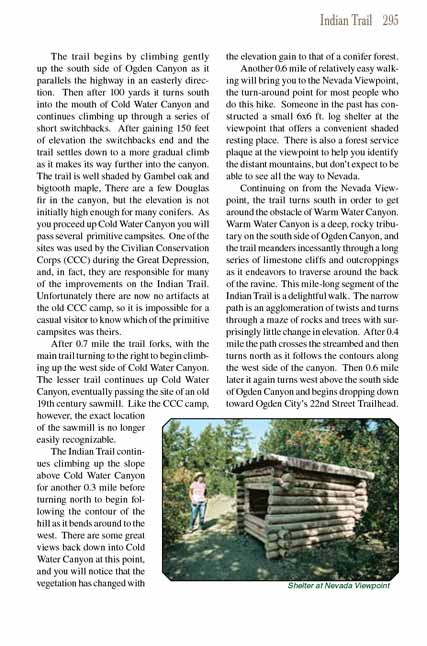
The Indian Trail is best done as a one-way hike with a shuttle car placed at the ending trailhead. The walk I describe here begins at the Cold Water Trailhead in Ogden
Canyon and ends at the 22nd Street Trailhead, but it could just as easily be done in the opposite direction. A popular turn-around point for those who do not have
a shuttle car is the Nevada Viewpoint, where you will find a nice view of Ogden Canyon and North Ogden. There is also a small log shelter beside the trail at the
Nevada Viewpoint.
The Indian Trail begins by climbing gently up the south side of Ogden Canyon as it parallels the highway in an easterly direction. Then after 100 yards it turns south
into the mouth of Cold Water Canyon and continues climbing up through a series of short switchbacks. After gaining 150 feet of elevation the switchbacks end and
the Indian Trail settles down to a more gradual climb as it makes its way further into the canyon. The trail is well shaded by Gambel oak and bigtooth maple, There are
a few Douglas fir in the canyon, but the elevation is not initially high enough for many conifers. As you proceed up Cold Water Canyon you will pass several
primitive campsites. One of the sites was used by the Civilian Conservation Corps (CCC) during the Great Depression, and, in fact, they are responsible for many
of the improvements on the Indian Trail. Unfortunately there are now no artifacts at the old CCC camp, so it is impossible for a casual visitor to know which of
the primitive campsites was theirs.
After 0.7 mile the Indian Trail forks, with the main trail turning to the right to begin climbing up the west side of Cold Water Canyon. The lesser trail continues up
Cold Water Canyon, eventually passing the site of an old 19th century sawmill. Like the CCC camp, however, the exact location of the sawmill is no longer easily
recognizable.
The Indian Trail continues climbing up the slope above Cold Water Canyon for another 0.3 mile before turning north to begin following the contour of the hill as
it bends around to the west. There are some great views back down into Cold Water Canyon at this point, and you will notice that the vegetation has changed with
the elevation gain to that of a conifer forest.
Another 0.6 mile of relatively easy walking will bring you to the Nevada Viewpoint, the turn-around point for most people who do this hike. Someone in the past
has constructed a small 6x6 ft. log shelter at the viewpoint that offers a convenient shaded resting place. There is also a forest service plaque at the viewpoint
to help you identify the distant mountains, but don’t expect to be able to see all the way to Nevada.
Continuing on from the Nevada Viewpoint, the
Indian Trail turns south in order to get around the obstacle of Warm Water Canyon. Warm Water Canyon is a deep, rocky
tributary on the south side of Ogden Canyon, and the trail meanders incessantly through a long series of limestone cliffs and outcroppings as it endeavors to
traverse around the back of the ravine. This mile-long segment of the Indian Trail is a delightful walk. The narrow path is an agglomeration of twists and
turns through a maze of rocks and trees with surprisingly little change in elevation. After 0.4 mile the path crosses the streambed and then turns north as
it follows the contours along the west side of the canyon. Then 0.6 mile later
the Indian Trail again turns west above the south side of Ogden Canyon and begins dropping
down toward Ogden City’s 22nd Street Trailhead.
Note to web developers: You may copy this material onto your site, but in return please include a link to my home page
www.utahtrails.com. Thank you, David Day (utahdavidday at gmail.com)
Click here to see more
trails near Salt Lake City
© Rincon Publishing Company, all rights reserved
|