Clayton Peak Trail
from Guardsman Pass
excerpted from our book
Salt Lake City's Incredible Hiking and Biking Trails
pages 312-314
|
Buy book directly from the author!
Salt Lake City's Incredible Hiking and Biking Trails
- has access info for 73 trailheads
- 73 colorful trail maps
- 325 full color photographs
- loads of hiking tips
|
regularly $19.95
now on sale for only
$9.95
click here
for book orders
|
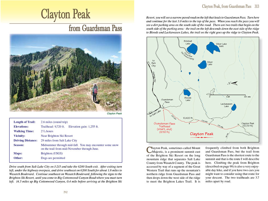
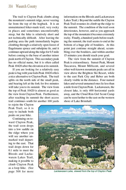
Clayton Peak, sometimes called Mount Majestic, is a prominent summit east of the Brighton Ski Resort on the long mountain ridge that
separates Salt Lake County from Wasatch County. The peak is accessed by way of a segment of the Great Western Trail that runs up the mountain’s northern ridge from
Guardsman Pass and then drops down the west side of the ridge to meet the Brighton Lakes Trail. It is frequently climbed from both Brighton and Guardsman Pass,
but the trail from Guardsman Pass is the shortest route to the summit and that is the route I will describe here. Climbing the peak from Brighton (described on
page 98) is also a very enjoyable day hike, and if you have two cars you might want to consider using that route for your descent. The two trailheads are 3.7
miles apart by road.
The trail to Clayton Peak climbs along the mountain’s summit ridge, never veering far from the top of the hogback. It is an unmaintained hiker-made trail, very
rocky in places and sometimes uncomfortably steep, but the hike is relatively short and not technically difficult. After leaving the parking area the path
immediately begins climbing through a relatively open forest of Engelmann spruce and subalpine fir, and it continues upward along the ridge for 0.5 mile before
coming to the base of another minor peak north of Clayton. This secondary peak has no official name, but it is often called Peak 10420 after the elevation at
its summit.
If you are looking for a relatively easy peak to bag with your kids Peak 10420 offers a nice alternative to Clayton Peak. The trail splits on the north side of
the small peak, and bearing left at the fork for five minutes will take you to its summit. The view from the top of Peak 10420 is almost as good as the view from
Clayton Peak. Furthermore, after reaching its summit the short access trail continues south for another 100 yards to rejoin the Clayton Peak Trail, so it is easy
to include both peaks on your hike.
Continuing on toward Clayton Peak, the trail soon drops into a low saddle on the ridge where you will see another unmarked trail departing to the east. That trail
drops down for 0.1 mile to meet the Bloods and Lackawaxen Lakes Trail, making it possible to climb Clayton Peak as a loop hike. (See page 308 for more information
on the Bloods and Lackawaxen Lakes Trail.) Beyond the saddle the Clayton Peak Trail resumes its climb up the ridge to the summit. The condition of the trail soon
deteriorates, however, and as you approach the top of the mountain it becomes extremely rocky. Finally, a hundred yards before reaching the summit, the trail seems
to end at the bottom of a huge pile of boulders. At this point just continue straight ahead, scrambling over the boulders, and within another 15 minutes you
should reach your goal.
The view from the summit of Clayton Peak is extraordinary. Sunset Peak, Mount Tuscarora, Mount Millicent, and several other well-known mountain peaks are all in
view above the Brighton Ski Resort, while to the east Park City and Heber are both clearly visible in the distance. Four named lakes and several unnamed ones lie
less than a mile from Clayton Peak. Lackawaxen, the closest lake, is only 400 horizontal yards away, and the Cloud Rim Girl Scout Camp can be seen further to the
east on the western shore of Lake Brimhall.
Note to web developers: You may copy this material onto your site, but in return please include a link to my home page
www.utahtrails.com. Thank you, David Day (utahdavidday at gmail.com)
Click here to see more
trails near Salt Lake City
© Rincon Publishing Company, all rights reserved
|