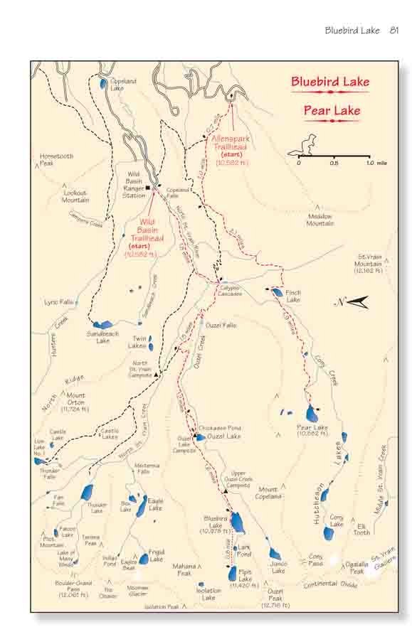
Isolated as it is in the southeastern corner of Rocky
Mountain National Park, Wild Basin seems almost to be a private reserve for
hikers. There are no paved roads here and no visitors centers-only pristine
alpine lakes, rushing waterfalls, and about 30 miles of foot trails. In 1974
the Park Service proposed that Wild Basin be included as part of a new Enos
Mills Wilderness Area. Congress still has not acted on their
recommendations, but to their credit they are already managing the area as
if it were a designated wilderness.
The hike described here visits three of Wild Basinís
lakes and three of its waterfalls. It can be done in one long day, but in my
opinion a single day is not enough to really appreciate the beauty of the
area. Unfortunately, the area is very popular among backpackers and the Park
Service will only allow campers in certain places, so reservations are a
necessity if you intend to spend the night on the trail. You can obtain a
reservation by calling the Backcountry Office of Rocky Mountain National
Park at (970) 586-1242 between March 1 and May 15 of the year you are
planning your trip. Sometimes camping permits can also be obtained without
reservations at the Wild Basin Ranger Station near the trailhead, but only
if there are sites available. The cost of a camping permit is $15.00/night.
The best campsite to use for this hike is the Upper Ouzel
Creek Site, located 0.4 mile below Bluebird Lake. This site is situated in a
picture book location with plenty of wild flowers, a cascading stream and a
tent site with an unforgettable view of the canyon below. The Ouzel Lake
Site is nice too, especially if you want to do a little fishing. A distant
third choice would be the North St. Vrain Site.
Day 1 (5.7 miles)
From the ranger station the trail starts out by following
the North St. Vrain Creek, a rocky, fast-flowing mountain stream that
sometimes seems to be just one continuous cascade. The torrent at Copeland
Falls, ten minutes from the trailhead, provides a good introduction to what
lies ahead. But donít stop too long-it gets better.
A mile beyond Copeland Falls the path crosses the North
St. Vrain Creek on a foot bridge, then climbs south along Cony Creek for a
short distance to the second point of interest: Calypso Cascades. Here the
turbulent water of Cony Creek makes its final, chaotic descent down a steep
ravine to the confluence of the two streams. The cold liquid dances wildly
over the granite boulders in a kind of animated mating ritual as it prepares
to join the equally restless North St. Vrain. Best of all, the trail crosses
Cony Creek on another foot bridge just below Calypso Cascades, so hikers
have a perfect vantage point from which to view to spectacle.
0.8 mile after leaving Calypso Cascades the trail comes
to another foot bridge across Ouzel Creek, where hikers can again witness an
impressive display of natures artistry. A hundred feet west of the bridge
the creek plunges over a 30-foot vertical drop in the streambed to form
Ouzel Falls. The view from the bridge is fair, but it is worthwhile at this
point to leave the established trail and proceed along a primitive
hiker-made trail on the south side of the stream to the base of the
waterfall. Your reward will be a face full of spray and a full frontal view
of Ouzel Falls.
Before the trail reaches Ouzel Falls you will begin to
notice signs of a forest fire that occurred in 1978 after a lightening
strike near Ouzel Lake. Twenty minutes after leaving the Falls the trail
comes to a junction where the Bluebird Lake Trail separates from the Thunder
Lake Trail, and as you climb out of the North St. Vrain Drainage towards
Bluebird Lake the fire damage becomes much more pronounced. The fire burned
for two months and destroyed a total of 1050 acres before fire fighters
could extinguish it.
It has been 30 years since the fire and nature is
well on the way to repairing the damage. Notice the thousands of little
lodgepole pines that are springing up throughout the burned areas.
Lodgepole pines are always among the first trees to germinate after a
fire in this region. In fact they do not reproduce well in the absence
of fire because the treeís resin cements the cones together so tightly
that the seeds cannot easily be released. But when a fire like 1978 Wild
Basin Fire takes place it softens the resin in the lodgepole pinecones
and scatters millions of new seeds across the blackened landscape.
Ouzel Lake lies on the left side of the trail 1.6
miles from the Thunder Lake Trail Junction. If you are planning to camp
there you will be pleased to see that the fire never quite reached the
shore of the lake, and it remains a beautiful place to spend the night.
The campsite is at the end of the spur trail leading to the north side
of the lake. The lake is quite shallow, but nevertheless a significant
population of brook trout and greenback cutthroat trout manages to
survive the winters, making Ouzel a popular lake for fly fishermen. The
greenback cutthroats are unusually pretty fish, with spotted green backs
and blood red gills. They are a threatened species, however, and the
Park Service requires you to use barbless hooks and release any
greenbacks you might catch.
The Upper Ouzel Creek Campsite is situated another
mile past Ouzel Lake, beyond the western boundary of the 1978 fire. This
site would be my first choice for this hike. The Upper Ouzel Creek Site
is conveniently located near Bluebird Lake, and, in my opinion, it is
also one of the prettiest and most comfortable campsites in Rocky
Mountain National Park.
Day 2 (8.1 miles)
After leaving the Upper Ouzel Creek Campsite the
trail becomes much steeper, climbing 400 feet before it reaches Bluebird
Lake, 0.4 mile later. The trail is also much more primitive here, and if
you are hiking before mid-July you will probably encounter snow on this
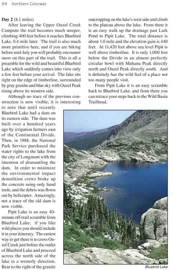
part of the trail. This is all a preamble for the wild and beautiful
Bluebird Lake which suddenly comes into view only a few feet before your
arrival. The lake sits right on the edge of timberline, surrounded by
gray granite and blue sky with Ouzel Peak rising above its western side.
Although no trace of the previous construction is now
visible, it is interesting to note that until recently Bluebird Lake had
a dam on its eastern side. The dam was built over a hundred years ago by
irrigation farmers east of the Continental Divide. Then, in 1988, the
National Park Service purchased the water rights to the lake from the
city of Longmont with the intention of dismantling the dam. In order to
minimize the environmental impact demolition crews broke up the concrete
using only hand tools, and the debris was flown out by helicopter.
Amazingly, not a trace of the old dam is now visible.
Pipit Lake is an easy 40-minute off-trail scramble
from Bluebird Lake; if you like wild places you should include it in
your itinerary. The easiest way to get there is to cross Ouzel Creek
just before the outlet of Bluebird Lake and proceed across the north
side of the lake in a westerly direction. Bear to the right of the
granite outcropping on the lakeís west side and climb to the plateau
above the lake. From there it is an easy walk up the drainage past Lark
Pond to Pipit Lake. The total distance is about 1.0 mile and the
elevation gain is 440 feet. At 11,420 feet above sea level Pipit is well
above timberline. It is only 1,000 feet below the Divide in an almost
perfectly circular bowl with Mahana Peak directly north and Ouzel Peak
directly south. And it definitely has the wild feel of a place not too
many people visit.
From Pipit Lake it is an easy scramble back to Bluebird Lake, and
from there you can retrace your steps back to the Wild Basin Trailhead.

