|
Links to other sites:
Do you have any recent information to add about this trail?
Ordering books & Maps
Free sample copies of Outdoor Magazines
Comments about this site or our book:

|
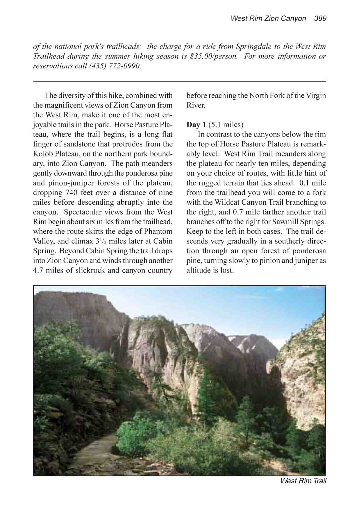
The diversity of this hike,
combined with the magnificent views of Zion Canyon from the West
Rim, make it one of the most enjoyable trails in the park. Horse
Pasture Plateau, where the trail begins, is a long flat finger
of sandstone that protrudes from the Kolob Plateau, on the northern
park boundary, into Zion Canyon. The path meanders gently downward
through the ponderosa pine and pinon-juniper forests of the plateau,
dropping 740 feet over a distance of nine miles, before descending
abruptly into the canyon. Spectacular views from the West Rim
begin about six miles from the trailhead, where the route skirts
the edge of Phantom Valley, and climax 3 1/2 miles later at Cabin
Spring. Beyond Cabin Spring the trail drops into Zion Canyon
and winds through another 4.7 miles of slickrock and canyon country
before reaching the North Fork of the Virgin River.
Day 1
In contrast to the canyons below
the rim, the top of Horse Pasture Plateau is remarkably level.
West Rim Trail meanders along the plateau for nearly ten miles,
depending on your choice of routes, with little hint of the rugged
terrain that lies ahead. 0.1 mile from the trailhead you will
come to a fork with the Wildcat Canyon Trail branching to the
right, and 0.7 miles farther another trail branches off to the
right for Sawmill Springs. Keep to the left in both cases. The
trail descends very gradually in a southerly direction through
an open forest of ponderosa pine, turning slowly to pinion and
juniper as altitude is lost.
About 3.5 miles from the Sawmill
Springs junction you will begin dropping into Potato Hollow,
a shallow drainage that leads to a side canyon on the west side
of the plateau. A large grove of quaking aspen occupies the hollow,
and the small pond near the canyon rim is a favorite afternoon
watering hole for wildlife. The rim of the plateau is just west
of the pond, and there are some fine views of Imlay Canyon from
there.
Potato Hollow is a delightful place
to make camp for the night, but in order to minimize your impact
try to select a spot at least a few hundred yards from the pond
itself. Also, bear in mind that open fires are not allowed. Be
sure to watch the pond in the late afternoon, as you are almost
certain to see deer coming for water. If it is still too early
in the day to stop when you reach Potato Hollow you may want
to continue on for another 4.6 miles to Cabin Spring. But Potato
Hollow is such a pleasant place to spend the night it is a shame
to pass it by.
Day 2
About a mile below Potato Hollow
the trail crosses Sleepy Hollow, where you will be treated to
a panorama of Phantom Valley. On the opposite side of the valley
you can also see Greatheart Mesa, one of the landmarks of the
park. Another 0.3 mile will bring you to another trail junction
where a decision has to be made. The Telephone Canyon Trail,
on the left is the shorter route to Cabin Spring, but unless
you are in a terrible hurry you should bear to the right here
and follow the rim trail. It is 1.4 miles longer, but much more
scenic.
The rim trail skirts the southeastern
side of Horse Pasture Plateau and affords almost continual views
of Phantom Valley and Heaps Canyon below. Telephone Canyon is
a more densely forested route that cuts through the center of
the plateau to meet the rim trail again at Cabin Spring. The
rim trail encounters another fork 1.7 miles from the Telephone
Canyon trail junction, and once again you should keep to the
right. The other trail is, again, a shortcut which would save
you 0.1 mile, but at the cost of the scenic rim views.
Cabin Spring is a good place to
stop for lunch. The spring itself is quite unimpressive. It was
named after a park service cabin that once stood nearby but unfortunately
burned down in the 1970s. From the rim near Cabin Spring, however,
you can see a long stretch of the trail below, and it is interesting
to gaze down into the slickrock canyon country and trace out
the route you will follow below the plateau.
Beyond Cabin Spring the trail begins
to descend almost at once, making two long switchbacks down the
sandstone cliffs into the canyon below. After loosing about 900
feet you will arrive at a point directly below and to the east
of the spring; look back and see the water-streaked cliffs beneath
it. Immediately to your right is Mount Majestic and, behind that,
Cathedral Mountain. You will spend the next two miles skirting
around these two formations to reach Refrigerator Canyon.
After you have walked 2.8 miles
from Cabin Creek you will see a spur trail on the left heading
for the top of a rocky peak known as Angels Landing. If you have
the time, Angels Landing is a side trip that shouldn’t be
missed. The top is only 0.5 mile from the main trail, and the
view is absolutely incredible. The river winds around a huge
270 degree bend in the canyon, and on the road 1470 feet below
cars creep like ants on their way to and from the Temple of Sinawava.
The Great White Throne, probably the most famous of Zion’s
landmarks, rises 3,420 feet above the canyon floor on the opposite
side of the river. A word of caution, however, about the “trail”
to Angels Landing. Some scrambling is necessary and, although
the park service has installed rails and support chains on a
few of the more exposed sections, the route is not for the faint
of heart. Small children and people who suffer from vertigo should
not attempt this hike. Angels Landing is especially dangerous
when it is wet or windy. Also, the top of the ridge is frequently
struck by lightning, so avoid it during stormy weather.
If you decide not to attempt Angel’s
Landing, at least pause to enjoy the view from Scout Lookout,
near the trail junction. Leaving Scout Lookout, the trail drops
straight down into Refrigerator Canyon over a series of no less
than 21 switchbacks. These switchbacks, whimsically called Walter’s
Wiggles, were cut from the rock cliff in 1926 so that tourists
could reach the viewpoints above. Viewed from a distance they
look more like a rope ladder or a spider’s web than a trail.
Finally, after following the bottom
of Refrigerator Canyon for about a half mile, the trail emerges
on the west side of the inner canyon and threads its way down
to the river, 1.9 miles from Scout Lookout. |