|
Links to other sites:
Do you have any recent information to add about this trail?
Ordering books & Maps
Comments about this site or our book:

|
Hikers planning a trip to the
scenic Red Castle Lakes on the north slope of the High Uintas
generally have two different trails to choose from: the East
Fork Smiths Fork Trail or the Bald Mountain Trail. The first
route, beginning at China Meadows and following the East Fork
Smiths Fork all the way to its source, is the most popular route.
The East Fork Smiths Fork Trail is very well maintained and has
a total elevation gain (to Lower Red Castle Lake) of only about
1,280 feet. The Bald Mountain Route, on the other hand, is much
more strenuous. It begins at East Fork Blacks Fork and climbs
over Bald Mountain Ridge before reaching the lower lake, achieving
an elevation gain of 2,190 feet. Both trails are within a quarter
mile of the same length.
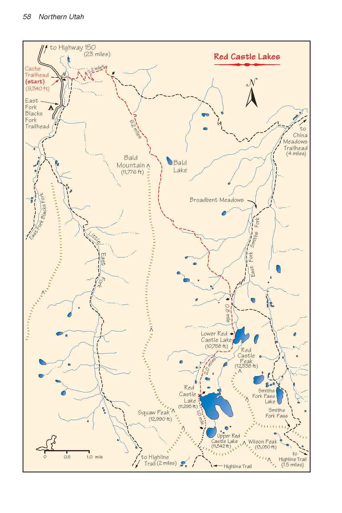
I have chosen here to describe
the Bald Mountain route to the Red Castle Lakes, primarily because
it is the most scenic of the two. The additional 900 feet of
elevation gain is compensated for by the fine views that can
be had from Bald Mountain Ridge. The trail follows the grassy,
treeless ridge at an elevation of 11,500 feet for almost two
miles before dropping down to the East Fork Smiths Fork drainage,
and Red Castle Peak occupies a prominent place on the skyline
for almost the entire distance.
The most interesting way to see
the Red Castle Lakes is to hike in on the Bald Mountain Trail
and hike out on the East Fork Smiths Fork Trail to China Meadows.
Not many people do this, however, because the two trailheads
are 50 miles apart. (See pages 61-62 for instructions on how
to get to China Meadows.)
Day 1
From Cache Trailhead the Bear River-Smiths
Fork Trail heads east and, after about 200 yards, crosses the
East Fork Blacks Fork Creek. It will be necessary to get your
feet wet here, as there is no bridge and no stepping stones crossing
the creek. Normally the water is only ankle deep, but if there
has been a lot of rain you might want to consider beginning your
hike 0.6 miles farther down the road at the East Fork Blacks
Fork Trailhead, where the forest service has constructed a bridge.
There is a convenient connecting trail joining the east side
of the bridge with the Bear River-Smiths Fork Trail. Of course,
if you do this the hike will be 0.6 miles longer.
Once it crosses the river the trail
almost immediately starts upward, gaining a little over a thousand
feet in the next two miles. After reaching the top of the ridge
it temporarily levels out and meets the Bald Mountain trail junction.
Bear to the right here, as indicated by the sign. Soon the path
begins to climb again and within a mile you will be above timberline.
Bald Mountain (11,776 ft.) is the large, gently sloping dome
in front of you.
At its highest point the trail
passes within 0.3 miles of the top of Bald Mountain. If you want
to make a detour to the summit it is an easy off-trail walk,
with only 250 feet of elevation gain. On the other side of the
trail, about 300 yards to the east is Bald Lake. The lake is
so close it almost seems as though you could hit it from the
trail with a rock, but because it is 450 feet lower it is seldom
visited.
From Bald Mountain the trail continues
to meander along the top of Bald Mountain Ridge for another 1.3
miles before dropping into the East Fork Smiths Fork drainage.
The remaining three miles to Lower Red Castle Lake is a beautiful
walk through scattered forest and meadow land, with lots of water
and good camping spots. If you got off to a late start you won’t
have any problem finding a place to spend the night. This is
also a summer grazing area for sheep ranchers, and you will probably
see signs of sheep if not the sheep themselves.
Finally, a mile after the trail
reaches East Fork Smiths Fork, you will come to Lower Red Castle
Lake. There are several good camping spots near the trail on
the west side of the lake, and the views of Red Castle Peak are
fabulous. After supper you will probably want to spend an hour
beside the lake watching the reflections while the last rays
of sunset transform the Castle into a glowing ember of red.
Day 2
From Lower Red Castle Lake it is
a pleasant 6-mile round trip hike to the two upper Red Castle
Lakes. The scenery is excellent, but there are no good camping
spots at Red Castle or Upper Red Castle Lake, so leave your camp
at the lower lake. The trail continues up the west side of Lower
Red Castle Lake, then bends around the west side of the Castle,
finally reaching Red Castle Lake on its northern side. Red Castle
Lake is 537 feet higher than Lower Red Castle which places it
well above timberline. Consequently, there are no trees whatsoever
around the higher lake.
From this vantage point you can
see that the Red Castle Peak is actually the end of a short spur
that extends northward from Wilson Peak on the Uinta Crest. The
formation seems oddly out of place, because although the Uinta
Crest is composed almost entirely of gray colored Precambrian
quartzite the Red Castle is composed primarily of sandstone and
shale based material. As a result the castle-shaped peak is not
only a different color than the other surrounding peaks, but
it has eroded into an entirely different form. Because of the
contrast, this rugged peak is probably the most picturesque summit
in the entire range.
On the northwestern corner of Red
Castle Lake you will find a well cairned trail leading up the
talus slope toward Upper Red Castle Lake. The route is not difficult,
and the elevation gain to Upper Red Castle is only 247 feet.
Upper Red Castle Lake is a small, rocky lake, about 200 yards
in diameter. It is fed entirely from the melting snows on the
higher slopes of Red Castle Basin and it is not very deep; hence
its size varies a great deal from year to year.
The primitive trail from Red Castle
Lake does not stop at Upper Red Castle Lake, but continues upward
to a small pass on the ridge 628 feet above Upper Red Castle.
The extensive Highline Trail is only 0.2 mile south of this low
point on the ridge; hence there are many possibilities for extended
backpacking trips from Upper Red Castle Lake. Squaw Pass, for
instance, is 3.5 miles west along the Highline Trail, and from
there it is possible to walk back along the Little East Fork
Trail to Cache Trailhead where the hike began. Another possibility:
Kings Peak, the highest point in Utah, is only ten miles east
along the Highline Trail.
Day 3
The hike back to Cache Trailhead
from Lower Red Castle Lake is just the reverse of Day 1. The
return is much less tiring, however, since the elevation gain
required to get back on Bald Mountain Ridge is only 770 feet,
and from there the hike is all downhill. |

