|
Links to other sites:
Ordering books & Maps
Comments about this site or our book:

|
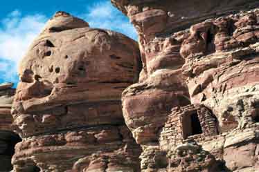
Southeastern Utah has one of
the largest concentrations of Anasazi Indian ruins in the United
States, and the area around Owl Creek and Fish Creek is one of
the best places to see them. Most of the ruins in these two canyons
are, unfortunately, located high on the cliffs in inaccessible
alcoves. They are not generally obvious to the casual observer,
and many hikers complete the loop having seen only one or two
ruins. There is one excellent site, however, which is right on
the trail in Owl Creek Canyon, so everyone can be assured of
seeing at least one ruin site.
You will have better luck in finding
the Anasazi ruins if you know where to look. First, bear in mind
that these canyons are cold in the wintertime, and the inhabitants
preferred to build their homes where they could get as much winter
sunshine as possible. That means on the south-facing, or north
side of the canyon. Rarely will you see a ruin on the south side
of a canyon. Second, the Indians tended to live as close as possible
to the land they were farming; consequently there are more ruins
in those areas where the canyon bottom is wide and flat. In places
where the canyon bottom is too narrow or rocky the Indians farmed
above the rim, and in those locations the ruins will be nearer
to the top. When looking for cliff dwellings it helps to have
a small pair of lightweight binoculars. I spotted seven ruin
sites the first time I walked this loop, but two or three of
them would have been impossible to identify without binoculars.
Indian ruins are not the only attraction
this hike has. There is also plenty of interesting scenery-especially
in Owl Creek Canyon. The reddish colored Cedar Mesa Sandstone
has been carved into an eye-catching display of pinnacles and
spires, and at least three natural arches. Nevills Arch, about
half way up Owl Creek Canyon, is particularly impressive. There
are also a number of fine camp sites in both canyons-particularly
near the confluence.
The loop can be walked in either
direction. The ranger station recommends that hikers go down
Owl Creek Canyon first, primarily because the trail down from
the rim of Fish Creek Canyon is rather steep and rocky, and it
is easier to climb out of that canyon with a pack than to climb
into it. Personally, however, I feel it is best to go down Fish
Creek first and exit through Owl Creek Canyon. I prefer that
direction, first, because the trail in upper Fish Creek Canyon
is sometimes vague, and one can easily miss the turn where the
trail starts up to the rim. Second, there is more to see in Owl
Creek Canyon, and I like to save the best for last.
Day 1
From the parking area walk north
on a well-trodden path for 1.7 miles to the edge of Fish Creek
Canyon. The canyon rim, incidentally, is a good place to camp
if you are getting off to a late start. Before dropping below
the rim look carefully along the bottom of the cliffs on the
opposite side of Fish Creek Canyon, and if you have sharp eyes
you may spot your first ruin. The remains of a small, square,
stone dwelling with a door on the right side are located there.
The structure is quite far away, and with the unaided eye it
is difficult to positively identify it as man-made. But with
binoculars you will be able to see the telltale pattern of brick
work and the log beams that once supported the roof.
Shortly after leaving the rim the
trail comes to a ten-foot ledge that can be troublesome getting
down with a backpack. The best way to negotiate this obstacle,
especially if you are hiking alone, is to lower your pack to
the bottom with a short piece of rope before climbing down. The
remainder of the trail down to the canyon floor is quite steep
and rocky, but well marked with stone cairns. Take care not to
twist an ankle. Once you reach the canyon floor the walking is
much easier.
There are not as many Indian ruins
in upper Fish Creek Canyon as their are along Owl Creek; hence
the 7.9 mile walk down Fish Creek to the confluence with Owl
Creek is rather uneventful. I was only able to see one other
cliff dwelling along this section of the hike. The canyon is
quite rugged, however, and there is some interesting scenery.
There are also at least two unnamed natural arches in upper Fish
Creek Canyon, but unless you watch the canyon walls carefully
you may not see both of them. As you approach the confluence
the canyon widens, the juniper forest thins out, and more cottonwood
trees can be seen. The best camp sites are in the immediate vicinity
of the confluence.
If you have time after pitching
camp you may want to leave your pack behind and continue down
into lower Fish Creek Canyon for a few miles. The canyon floor
is wide and flat in this area and the walking is fast and easy
along a good trail. There are a lot of ruins along lower Fish
Creek, some of them quite well preserved and easy to get to.
This area was probably extensively farmed by the Anasazis. The
first ruin in lower Fish Creek Canyon is located just above the
confluence with McCloyd Canyon, about a half-hour walk from Owl
Creek. Look to the left as the trail crosses a grassy meadow
under a large, partially fallen cottonwood tree. It is not too
difficult to climb up to this ruin, and a few pottery shards
are still visible near it. Please don’t remove anything,
however. Such artifacts have far more meaning if they are seen
in the wild where their original owners left them than they could
ever have in your private collection. And the thousands of others
who will come into the canyons after you will be equally delighted
to see the 700-year-old treasures. There are several other ruins
in lower Fish Creek Canyon, and also in McCloyd Canyon. You may
want to spend an extra day in the area to examine them.
Day 2
Today will be spent climbing out
of Owl Creek Canyon. The first half of the trail is flat and
easy, through an area that was undoubtedly farmed by the Anasazis.
Again, the canyon walls have been carved into an impressive array
of columns and monoliths that stand like sentinels above the
canyon. The most impressive geologic formation, however, is Nevills
Arch, located 2.0 miles above the confluence. This huge arch,
high on the canyon’s north side, would be impressive in
any setting, but seeing it in the wilderness of Owl Creek Canyon
is especially memorable. There are at least three Anasazi cliff
dwellings within a half-mile of the arch, and its presence surely
played an important role in their lives. It is a pity that today
we know nothing of what the arch meant to the canyon people,
or even what they called it.
Soon after Nevills Arch the canyon
narrows, and the trail passes several small waterfalls as it
slowly winds its way upward. There is usually not enough water
in Owl Creek to present much of a spectacle at the falls, but
they generally have at least a little water flowing over them.
Two of the falls have fine swimming holes at the bottom-clear
pools of water that have probably been a child’s delight
for a thousand years. The last fall, located about 2.1 miles
from the arch, effectively blocks the canyon floor, forcing the
trail to make a 0.4 mile detour into a side canyon to get around
it.
Finally, about 0.1 mile below the
canyon rim, the trail passes a hidden cliff dwelling with an
exceptionally well preserved Kiva as its centerpiece. Many of
the juniper beams that once supported the structure’s round
roof are still in place, and its cylindrical walls are almost
entirely intact. This ruin has been exceptionally well preserved
because it is located in a deep alcove, well sheltered from the
wind and the rain. It must have been bitter cold here in the
winter, however, as little sun ever reaches the alcove. Perhaps
the Indians had their winter living quarters elsewhere, and used
this site primarily for grain storage and religious activities.
From this last Anasazi ruin a crude,
cairn marked trail climbs straight up the slickrock drainage
to the rim above. Once you climb out of the canyon, continue
following the cairns in a northerly direction for another 0.3
mile to reach the parking lot where the hike ends. |