|
Links to other sites:
Ordering books & Maps
Comments about this site or our book:

|
The Maze District of Canyonlands
National Park, separated from the rest of the park by the Green
and Colorado Rivers, is one of the most rugged and remote desert
areas in the United States. As described above, just getting
there requires seven bone rattling hours of driving across a
narrow unimproved road, the last fourteen miles of which cannot
be completed without a 4WD vehicle. To their credit, the National
Park Service intends to preserve the remoteness, and there are
no plans to improve the access road. Indeed, there could hardly
be a more appropriate preamble to an experience in the Maze than
the long journey across the open desert required to reach it;
the rugged canyon country’s isolation definitely adds its
appeal.
The Maze, which actually occupies
only a small part the Canyonlands Maze District, includes about
thirty square miles of land, etched and sliced apart by five
major canyons and dozens of smaller side canyons. How could such
a small piece of land be carved into so many canyons? From the
plateaus above it looks like a labyrinth with the top removed.
A convoluted work of art, tenaciously sculpted by ten million
years of rainwater searching for a way to the Colorado River.
This loop hike affords fine views
of the Maze from the upper plateaus, as well as the experience
of walking through one of the canyons below. In addition, the
trail also passes by the Harvest Scene pictograph panel, considered
to be one of the finest examples of Archaic Indian rock art in
the Southwest. Many hikers complete the basic loop in one day,
but spending an extra night in the canyons will allow you to
include a side trip to the Maze Overlook, the best single place
to see the Maze from above. Also, it would be a shame not to
spend part of a day exploring a few side canyons before climbing
back to the trailhead.
Day 1
There are four cairned trails leaving
from the Chimney Rock parking area. The first trail on the left,
bearing around the west side of Chimney Rock, leads to the bottom
of Pictograph Fork. When you return to the trailhead at the end
of the loop you will be on this trail. The second trail from
the left passes by the east side of Chimney Rock and heads north
across the plateau above Pictograph Fork. The hike starts on
this trail. (The third and forth trails from the left lead to
Jasper Ridge and Water Canyon, respectively.)
As you walk northward across the
slickrock from Chimney Rock you will see Petes Mesa directly
in front of you. The large butte behind Petes Mesa is Ekker Butte.
If you loose track of the cairns just stay high on the ridge
as you continue towards Petes Mesa. When you get to within a
half mile of the mesa, however, be sure to watch more carefully
for the cairns so you will not miss the turn when the trail begins
its descent down into Maze. Also, be on the lookout for mountain
sheep in this area. They are often sighted on the plateau near
Petes Mesa.
Once you reach the bottom of the
Maze you will be on the sandy floor of a small side canyon leading
in a northwesterly direction. Soon you should see three large
red rocks that look like a grove of mushrooms growing out of
the edge of the rim about a mile down the canyon. This rock formation
lies just below the Maze Overlook.
Within fifteen minutes after you
spot the mushroom rocks you will pass by another major canyon
entering the drainage from the south. This is Pictograph Fork,
the canyon containing the famous Harvest Scene pictograph panel.
There are several other smaller side canyons in the area, but
Pictograph Fork is the largest one. It is nearly 200 yards wide
at the junction, with a 150-foot-wide span of slickrock in the
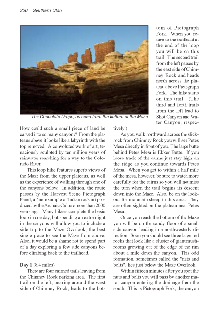
center of the stream bed. Also the Chocolate Drops formation
is clearly visible from the canyon mouth. This junction is a
very pleasant place to stop for the night. There are several
good campsites in the area and it is also a good base from which
to take a side trip to the Maze Overlook.
Maze Overlook
If you got off to a late start
you may want to wait and see the Maze Overlook in the morning.
But if you plan to take photographs it is best to be there in
the afternoon when the sun is in the west. Plan on about two
hours for the walk from the mouth of Pictograph Fork to the overlook
and back.
From the mouth of Pictograph Fork continue walking northwest
along the floor of the Maze towards the mushroom formation. After
0.5 mile the drainage dead ends at South Fork Horse Canyon. Turn
left here and walk south for another 0.3 mile to a point where
a break in the canyon wall provides access to the rim above.
The cairned trail up to the rim begins on the end of a long toe
of sandstone that protrudes into South Fork from the west rim.
Look for the cairns marking the canyon exit point. Also there
is a spring in the canyon at the end of the toe, and there is
usually a large pool of water in the stream bed at the point
where the route starts up.
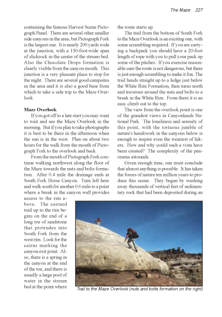
The trail from the bottom of South
Fork to the Maze Overlook is an exciting one, with some scrambling
required. If you are carrying a backpack you should have a 20-foot
length of rope with you to pull your pack up some of the pitches.
If you exercise reasonable care the route is not dangerous, but
there is just enough scrambling to make it fun. The trail heads
straight up to a ledge just below the White Rim Formation, then
turns north and traverses around the stone mushrooms to a break
in the White Rim. From there it is an easy climb out to the top.
The view from the overlook point
is one of the grandest views in Canyonlands National Park. The
loneliness and serenity of this point, with the tortuous jumble
of natures handiwork in the canyons below is enough to inspire
even the weariest of hikers . How and why could such a vista
have been created? The complexity of the panorama astounds.
Given enough time, one must conclude
that almost anything is possible. It has taken the forces of
nature ten million years to produce this scene. They began by
washing away thousands of vertical feet of sedimentary rock that
had been deposited during an earlier era to get down to the 250-million-year-old
Cedar Mesa Sandstone, from which the Maze was sculpted. The excavation
is ongoing, and is still not complete. Here and there one can
see remnants of younger rock that still has not been entirely
removed: Chimney Rock, the Chocolate Drops, Lizard Rock, the
Standing Rocks. Everything else has already been washed down
and swept away by the relentless Colorado River. Presently the
Maze itself is slowly being etched and chiseled away by the rain
and the sun and washed to the sea by the river. The dramatic
scene we see now represents only a brief interlude in the long
evolution of the Colorado Plateau.
Day 2
From the mouth of Pictograph Fork
it is 0.7 miles up the dry canyon to the Harvest Scene pictograph
panel. The panel is located at the bottom of the cliffs, about
ten feet above the west side of the stream bed. You will find
it about three hundred yards before you come to a thumb-shaped
pillar of sandstone in the bottom of the canyon.
No reliable method has yet been
developed for dating Indian rock art, but most archeologist believe
that the Harvest Scene was painted by the Archaic People who
lived in Utah from 8,000 to 2,000 years ago. These are the same
people who produced the famous Great Gallery pictographs 18 miles
to the north in Horseshoe Canyon (see page 191). The Archaic
People, who predated the better known Anasazi, left few other
remnants of their ancient culture for us to study; hence archeologist
have long struggled to interpret their art. But deciphering the
paintings has proven just as difficult as dating them, and we
still know little about what they mean. In this panel, one of
the figures appears to be holding a sheaf of rice grass; hence
the name Harvest Scene.
Continuing up the canyon from the
Harvest Scene for another 1.6 miles will bring you to another
junction with a major side canyon. The trail splits at this point.
If you bear right you will be continuing up Pictograph Fork on
a little used trail that finally ends near the east end of Lizard
Rock. Most hikers, however, turn left at this junction and follow
the cairns up an easier route to the rim that finally ends at
the Chimney Rock Trailhead. |