|
Links to other sites:
Ordering books & Maps
Comments about this site or our book:

|
Horseshoe Canyon contains what is probably the finest
display of prehistoric Indian rock art in the United States. The famous
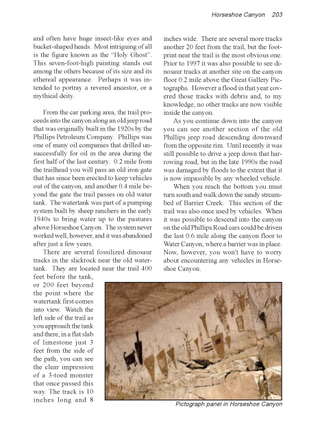
Great Gallery, largest of several Horseshoe Canyon sites, is 200 feet long,
15 feet high, and contains dozens of intriguing red, brown and white
pictographs. The paintings are at least 2,000 years old, and possibly as old
as 8,000 years. Rock art is notoriously difficult to date accurately, but
from the style we can be reasonably certain that the work was done by the so
called Archaic People who lived in the area before the arrival of the
Anasazi and Fremont Indian cultures. Archaic clay figurines that closely
mimic the pictographs have been found about nine miles away in Spur Fork, a
tributary of Horseshoe Canyon, and the figurines have been dated to about
4700 B.C.
For years archaeologists have struggled to interpret the
strange anthromorphs that are depicted in the Great Gallery. In addition to
many smaller figures, the huge panel contains about twenty life size human
shapes, all of which have a strange mummy-like appearance. They lack arms or
legs, and often have huge insect-like eyes and bucket-shaped heads. Most
intriguing of all is the figure known as the "Holy Ghost". This
seven-foot-high painting stands out among the others because of its size and
its ethereal appearance. Perhaps it was intended to portray a revered
ancestor, or a mythical deity.
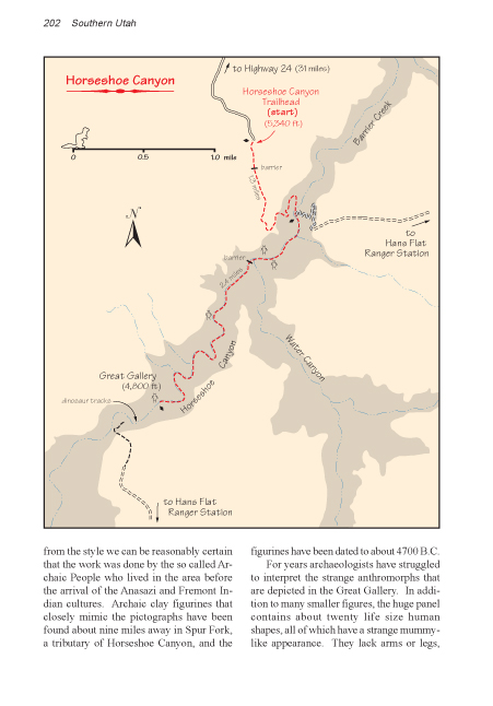
From the car parking area, the trail proceeds into the
canyon along an old jeep road that was originally built in the 1920s by the
Phillips Petroleum Company. Phillips was one of many oil companies that
drilled unsuccessfully for oil in the area during the first half of the last
century. 0.2 mile from the trailhead you will pass an old iron gate that has
since been erected to keep vehicles out of the canyon, and another 0.4 mile
beyond the gate the trail passes on old water tank. The watertank was part
of a pumping system built by sheep ranchers in the early 1940s to bring
water up to the pastures above Horseshoe Canyon. The system never worked
well, however, and it was abandoned after just a few years.
There are several fossilized dinosaur tracks in the
slickrock near the old watertank. They are located near the trail 400 feet
before the tank, or 200 feet beyond the point where the watertank first
comes into view. Watch the left side of the trail as you approach the tank
and there, in a flat slab of limestone just 3 feet from the side of the
path, you can see the clear impression of a 3-toed monster that once passed
this way. The track is 10 inches long and 8 inches wide. There are several
more tracks another 20 feet from the trail, but the footprint near the trail
is the most obvious one. Prior to 1997 it was also possible to see dinosaur
tracks at another site on the canyon floor 0.2 mile above the Great Gallery
Pictographs. However a flood in that year covered those tracks with debris
and, to my knowledge, no other tracks are now visible inside the canyon.
As you continue down into the canyon you can see another
section of the old Phillips jeep road descending downward from the opposite
rim. Until recently it was still possible to drive a jeep down that
harrowing road, but in the late 1990s the road was damaged by floods to the
extent that it is now impassible by any wheeled vehicle. When you reach the
bottom you must turn south and walk down the sandy streambed of Barrier
Creek. This section of the trail was also once used by vehicles. When it was
still possible to drive down the old Phillips Road from the east rim cars
would often continue of 0.6 mile up the canyon floor as far as Water Canyon
where a barrier was in place. Now, however, you won't have to worry about
encountering any vehicles in Horseshoe Canyon.
As you approach Water Canyon be sure to watch for the
first two pictograph sites, one on each side of the canyon. The trail passes
right by them. These sites, like the other two that you will see later, were
painted by the Archaic People between 2,000 and 8,000 years ago. The third
site is situated in a huge alcove on the west side of the stream, about 0.6
mile up-canyon from the first two. Unfortunately the alcove site has
sustained substantial damage, both natural and man-caused, and it is not as
impressive as the others.
Finally, 1.3 miles from the alcove site, or 3.7 miles from the beginning
of the trail, you will come to the Great Gallery. This display of rock art
has been called the Louvre of the Southwest, and, indeed, it is a phenomenal
relic of the past. Dozens of intricate human and animal figures decorate the
panel, mostly in red with some brown and white. The pigments were made from
finely ground minerals, mostly hematite, and then mixed with a liquid base,
perhaps animal tallow or vegetable juices, to form a crude paint. After
thousands of years all traces of the base have disappeared, but the mineral
coloring still adheres to the rock and the paintings remain preserved in
astonishing detail. |

