|
Links to other sites:
Do you have any recent information to add about this trail?
Ordering books & Maps
Free sample copies of Outdoor Magazines
Comments about this site or our book:

|
The Hackberry Canyon hike is
well suited to those backpackers who enjoy remote areas with
lots of solitude. It is in a rugged part of the state, between
the Kaiparowits Plateau and the Vermilion Cliffs, where there
are few good roads and fewer serious hikers. Unfortunately water
is also scarce in this region, and the first 11.3 miles of the
hike are waterless. Only after the gorge has cut nearly all the
way through the Navajo Sandstone to the top of the Kayenta Formation,
does a spring finally appear to wet the stark white sand on the
canyon floor. At this point the canyon begins to undergo a dramatic
change as the colors of life are added to the black and white
textures of upper Hackberry. In the next few miles even the walls
of the canyon change their hue from the harsh white of the Navajo
Formation to the softer reddish tones of the Kayenta Sandstone.
The plateaus above Hackberry have
been used by cattle ranchers since the 1800s, and traditionally
they have depended on the lower part of the canyon as a source
of water for their animals. A couple of trails into the canyon
are still occasionally used by local livestockmen, but human
activity is only a fraction of what it was at the turn of the
century.
Day 1
At the trailhead, where Rush Beds
road crosses the top of Round Valley Draw, the draw is very shallow
and uninteresting. The fun begins, however, about 0.5 mile further
down the streambed where, in order to continue, it becomes necessary
to climb down into a 20-foot-deep crack in the bottom of the
gully. The crack is only 12 to 18 inches wide-too narrow to negotiate
with a backpack-so you will have to lower your pack in with a
short rope before climbing down. The narrows continue for about
1.7 more miles before canyon opens up again. In at least three
more places you will meet interesting obstacles that have to
be dealt with. Again, your rope will come in handy for lowering
packs. At one point it will be necessary to crawl through a small
hole under a chock stone; at another your ability to get through
cracks will again be tested.
2.2 miles from the trailhead you
may see a large stone cairn on the north side of the canyon floor.
This marks the beginning of another trail coming down to Round
Valley Draw from Slickrock Bench. Day hikers can exit the draw
at this point and rimwalk back to their car on the Rush Beds
road. The narrows end here and the hike becomes an easy walk
along the dry, sandy streambed. After another 1.0 mile you will
arrive at the confluence with Hackberry Canyon.
Once you reach Hackberry Canyon
turn left and proceed in a southerly direction until you reach
water, 7.8 miles farther down the canyon. You will know you are
getting close when you see a few small cottonwood trees growing
in the sand. Then a short ways farther the sand will turn damp,
and finally you will start to see small pools of water along
the sides of the canyon. At about the point where the water first
starts to flow, 0.6 mile below the first cottonwoods, there is
a good camp site on a sandy knoll on the right side of the canyon.
This site has been used by cowboys for at least a hundred years.
It is also the trailhead for Upper Trail, an old cow trail leading
out of Hackberry Canyon to Death Valley. A short length of barbed
wire fence at the top of the knoll, and a near-vertical cliff
of Navajo Sandstone on the east side of the canyon will help
you identify the site.
Like many of the place names in
the West, there is an interesting story behind how Death Valley
got its name. Cattlemen have long used this valley as a winter
grazing pasture for their cattle. Their are no springs on the
plateau, however, and the cattle depend on Upper Trail for their
access to water. Oldtimers tell the story of how a cow once laid
down and died on a very narrow part of the trail near the rim.
The other cows were not able to get past the dead cow to go down
the trail for water and, as a result, many of them died of thirst
on the plateau above. Since that time the pasture has been known
as Death Valley.
Day 2
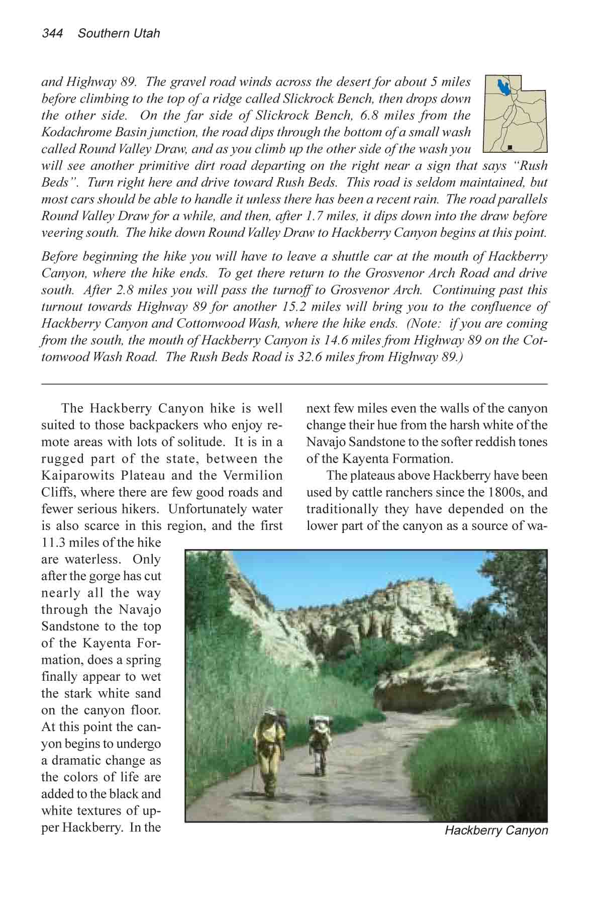
As you continue down Hackberry
Canyon from the campsite the water begins to flow a little faster,
but the stream is seldom more than a few inches deep. Dense vegetation
lines the banks, and the easiest place to walk is in the center
of the flat, sandy streambed. Wading shoes are very useful for
the remainder of the hike, as you will be in the water more than
half of the time.
After about ten minutes you will
pass another fence, built across the canyon floor to keep cattle
from wondering downstream, and a mile farther on you will see
Stone Donkey Canyon coming in from the right. Stone Donkey is
a box canyon with no access to the top, but it has nice spring
near its mouth which adds to the meager flow in Hackberry.
1.9 miles below Stone Donkey Canyon
there is a new feature in the canyon that was added in the fall
of 1987. In that year a large rock slide came down from the west
side of Hackberry, creating a dam across the canyon that backed
up the stream for several hundred yards. A number of dead cottonwood
trees reveal the size of the lake that was formed. The lake has
subsided now, however, and it is not difficult to find your way
across the rubble of the slide.
If you are observant you may see
another trail descending into Hackberry Canyon from the west
side a short distance upstream from the rock slide. This is the
Lower Trail, another cow trail leading up to Death Valley. Nearby,
the words “W.M. Chynoweth, 1892” have been scratched
into the canyon wall. The Chynoweths were a prominent ranching
family in southern Utah, and the name appears more than once
in the area’s cowboyglyphs.
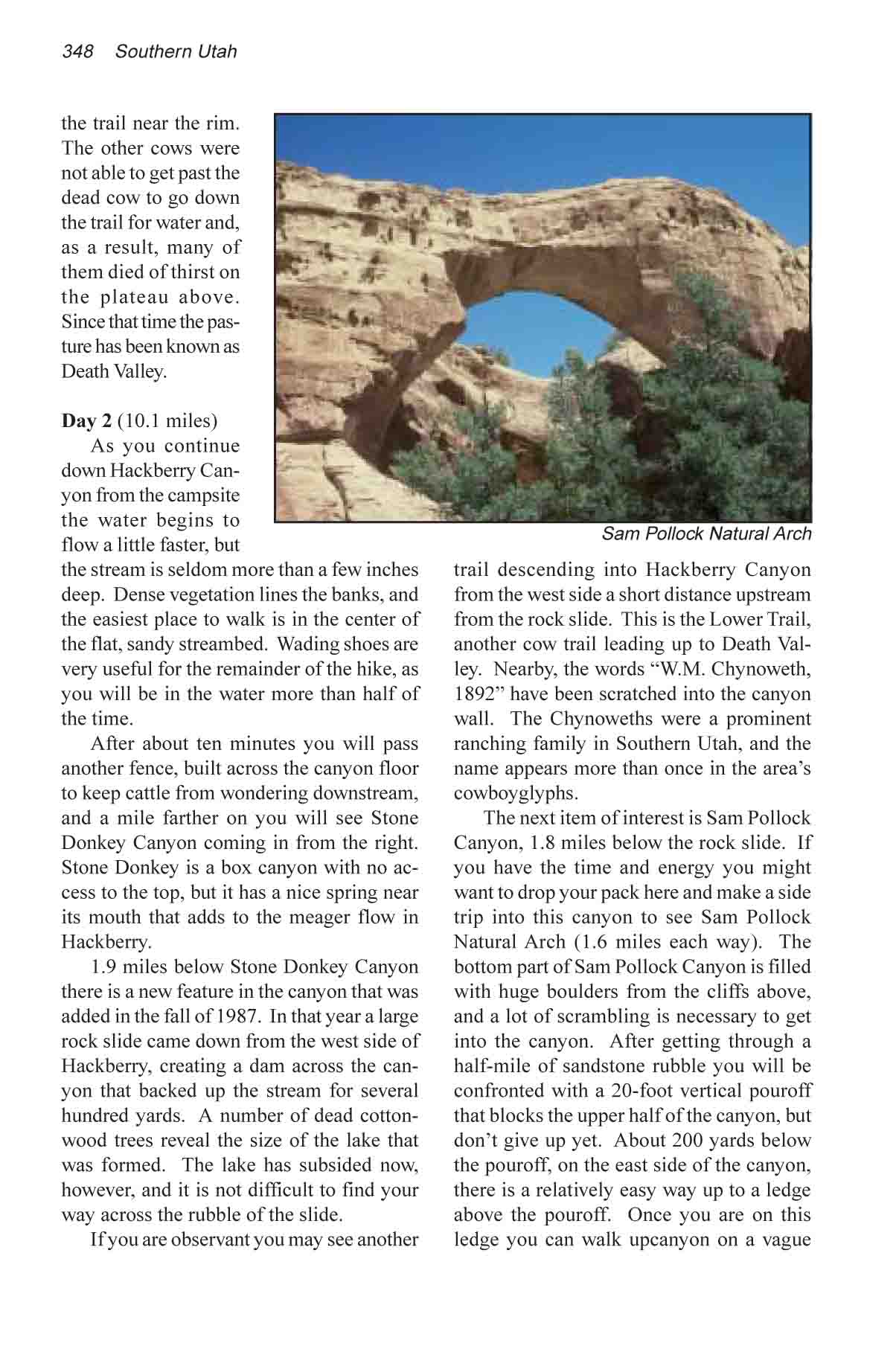
The next item of interest is Sam
Pollock Canyon, 1.8 miles below the rock slide. If you have the
time and energy you might want to drop your pack here and make
a side trip into this canyon to see Sam Pollock Natural Arch
(1.6 miles each way). The bottom part of Sam Pollock Canyon is
filled with huge boulders from the cliffs above, and a lot of
scrambling is necessary to get into the canyon. After getting
through a half-mile of sandstone rubble you will be confronted
with a 20-foot vertical pouroff that blocks the upper half of
the canyon, but don’t give up yet. About 200 yards below
the pouroff, on the east side of the canyon there is a relatively
easy way up to a ledge above the pouroff. Once you are on this
ledge you can walk upcanyon on a vague trail to a point just
above the pouroff and then drop 15 feet back down to the streambed.
The route is not difficult at all, but it is a little exposed
at one point so be careful with your footing.
Once above the pouroff it is an
easy 1.1 mile walk up the streambed to the arch, located near
the top of the canyon on the north side. There are also more
cowboyglyphs in the vicinity of Sam Pollock Arch. In a small
cave just north of the arch you can see a glyph scratched into
the rock by another member of the Chynoweth family: “Art
Chynoweth, 1912”.
Continuing down Hackberry Canyon,
be sure not to miss Frank Watson’s cabin. Watson migrated
to Utah from Wisconsin at the turn of the century. Upon his arrival
in Utah he changed his name, for reasons unknown, from Richard
Thomas to Frank Watson, and for the next fifteen years remained
completely out of touch with his relatives in Wisconsin. Many
people came west at that time to begin a new life, and few newcomers
were ever questioned about their past. Watson went to work for
a while in the nearby town of Pahreah (now a ghost town in Paria
Canyon), and in about 1914 he built his cabin in lower Hackberry
Canyon. The cabin is still in surprisingly good shape after all
these years.
The Watson cabin can’t be
seen from Hackberry creek, so it is easy to miss. It is situated
on the edge of a sagebrush-covered bench, some fifteen feet above
the west side of the streambed 0.6 miles downstream from the
mouth of Sam Pollock Canyon. As you walk downstream watch for
a large red sandstone boulder, about 15 feet in diameter, on
the west side of the stream. At the foot of this boulder you
should see a vague trail going up the side of the bank to the
cabin, which is hidden in the sagebrush only 100 feet away.
2.5 miles downstream from Watson’s
cabin Hackberry Canyon makes a sharp turn to the left and knifes
its way through a ridge known as the Cockscomb before converging
with Cottonwood Wash. For the last 1.8 miles the canyon narrows
to twenty or thirty feet, with cliffs of Navajo and Kayenta Sandstone
dropping precipitously from the convoluted Cockscomb to the waters
edge. It is very scenic. Finally Hackberry Creek emerges from
the ridge to join Cottonwood Wash and the road back to Kodachrome
Basin. |