|
Links to other sites:
Ordering books & Maps
Comments about this site or our book:

|
Grand Gulch is the premier area
in Utah to see the ruins of the prehistoric Anasazi Indians.
Their culture flourished in the canyon between 700 and 2000 years
ago, and today dozens of cliff dwellings and other stone and
mud structures remain to remind us of their occupancy. The most
obvious ruins are from the so called Pueblo III culture of the
thirteenth century, but more subtle remnants of the earlier Basketmaker
culture that existed in the canyon from 200 to 700 A.D. are also
present if one knows where to look.
By 1300 the Anasazi had deserted
Grand Gulch and the surrounding canyons and moved southeast into
the Rio Grande Valley of New Mexico. Precisely why they left
is not known for certain, but drought, depletion of natural resources,
and pressure from other nomadic Indians probably all played a
role. For the past seven hundred years the Anasazi homes have
stood in silence, clinging to the high canyon walls and causing
the occasional canyon visitor to stare in wonder.
The first known white men to see
Grand Gulch were the Mormons, who crossed Cedar Mesa in 1880.
Soon afterward a series of amateur archaeologists begin to arrive
in search of pots and other artifacts from the ruins. Between
1890 and 1897 at least nine expeditions entered Grand Gulch to
dig for artifacts. The most famous of these was lead by Richard
Wetherill, a rancher from southern Colorado who sold many Anasazi
artifacts to the American Museum of Natural History in New York.
Wetherill carved his name into the sandstone at several of the
sites he excavated.
Needless to say, these early explorers
did tremendous harm to the archeological record in Grand Gulch.
Now, of course, it is against the law to remove artifacts from
the canyons or to deface the ruins in any way. Please do not
carry out pottery shards, corn cobs, flint flakes, or any other
artifacts you may find laying on the ground. Also, do not climb
on the ruins, and try to stay off the middens as much as possible.
If everyone cooperates the wondrous Anasazi ruins of Grand Gulch
will be there for many more years to come, and our children will
have the opportunity to enjoy them as much as we do.
Day 1
From the top of Kane Gulch the
trail meanders gently downward for 3.8 miles before reaching
the bottom of Grand Gulch. You should see your first ruin high
on the southern wall of the Cedar Mesa Sandstone, about an hour
into the hike. This ruin is unusual in that it is on the north-facing
rather than the south-facing side of the canyon. The Indians
generally preferred to build their dwellings on the south-facing
side where they received more winter sun.
Upon reaching the bottom of Grand
Gulch you can’t miss seeing the extensive Junction Ruin
slightly upstream from the confluence. This area contains many
fine camping sites under the cottonwood trees, and if you got
a late start you may want to consider spending the night here.
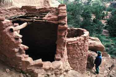
Junction is one of the largest
ruins in the canyon. It must have been home to many dozens of
Indians when they lived in the canyon, and the number of stone
buildings is impressive. It is also located near the stream bed
and is quite accessible. Unfortunately, the midden in front of
the ruin has been extensively excavated by amateur archaeologists
and pot hunters over the years. As a result of all the digging,
thousands of pottery shards, corn cobs and flints are now scattered
about the ground’s surface in front of the ruin. Enjoy the
patterns and designs on them, but, again, please leave them where
you find them so others can enjoy them too.
Turkey Pen Ruin, another large
accessible site, is only 0.7 mile below Junction Ruin, and fifteen
minutes later, if you have sharp eyes, you will see another less
accessible ruin in an alcove above the cottonwood trees. Finally,
2.5 miles below Turkey Pen Ruin, you will arrive at the mouth
of Todie Canyon, where I suggest you make camp.
Day 2
From Todie Canyon to Bullet Canyon,
the suggested camp site for the second day, you will scarcely
be able to walk a half hour without seeing a ruin of some sort.
By my count there are at least eleven distinct ruins sites in
the 8.4 miles between the two Canyons. Sometimes they consist
of only a small granary or two, and at other times they will
include the remains of fifteen or twenty buildings. The first
ruin is only a five minute walk from the mouth of Todie. Stay
on the right side of the canyon as you walk downstream, and you
will see it just as the stream bed swings around to the northeast.
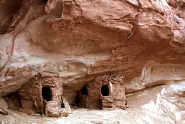
The most impressive ruin in this
section of the Grand Gulch is Split Level Ruin, so named because
it includes a structure with two adjoining rooms, one higher
than the other. Also notice, at this as well as other ruin sites,
the presence of many kivas. The kivas are the low, round shaped
structures, with a bench built into the wall and a fire pit near
one side. The present-day Hopi Indians have similar structures
in their pueblos, which leads many anthropologists to believe
that they are modern descendants of the Anasazis.
As the trail approaches Bullet
Canyon you will see the wide, flat-bottomed canyon opening up
on the left. The trail forks at Bullet Spring. There are no signs,
however, so take care not to miss the turn. There are several
excellent campsites within three hundred feet of the spring as
you proceed into Bullet Canyon.
If you have time after pitching
camp in Bullet Canyon you may want to spend an hour backtracking
to Shieks Canyon (1.4 miles upstream from Bullet in Grand Gulch).
There is an excellent panel of pictographs in the back of Shieks
Canyon, 15 minutes from its mouth. There is also an interesting
ruin on the canyon wall immediately above the Bullet Canyon camping
area, just a few hundred yards up Bullet Canyon from Grand Gulch.
Day 3
Most hikers complete the loop on
the third day, walking up Bullet Canyon to the trailhead above
the rim. There are at least five ruins to be seen in Bullet Canyon
on the way up, but the most interesting one is Jail House Ruin,
2.4 miles from the canyon mouth. You will know you have arrived
at Jailhouse Ruin when you see its unique pictograph consisting
of three large white circles. The circles can be seen all the
way across the canyon, but archaeologists have no idea what they
were meant to represent. The ruin was named Jailhouse because
of a small barred hole in the wall of one of its structures.
The nearby Perfect Kiva Ruin is also interesting. It contains
an extraordinarily well preserved kiva with a wooded ladder leading
down into its interior. There are no restrictions against entering
the kiva, but please take care not to damage it in any way.
As you proceed further up the canyon
it soon narrows and becomes much more rocky. There are no ruins
in upper Bullet Canyon, at least not that I was able to see.
The canyon bottom is completely unsuitable for farming here,
so if the Indians did build any dwellings they would most likely
be near the top of the rim. As you approach the top of the rim
you will be walking on slickrock part of the time, and there
are some areas where a bit of scrambling will be necessary. A
short piece of rope is useful for lifting backpacks in one or
two places, so that you can climb unencumbered. Be sure to watch
for rock cairns in the places where the canyon splits.
About ten minutes before you reach
the top of the rim look up on the north side at a square masonry
tower that was built by the Anasazis on the very edge of the
rim. Why would the Indians build a dwelling in such an exposed
place? Perhaps it was a watch tower or a monitoring station to
keep track of who was descending into the gulch. The parking
area is about a quarter mile beyond the square tower ruin. |