|
Links to other sites:
Ordering books & Maps
Comments about this site or our book:

|
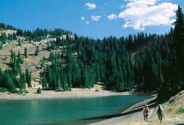
Desolation Lake is a popular
destination for mountain bikers, so you are bound to see a few
of them on this hike. But don’t expect all of them to be
riding-there is a 2,000-foot elevation gain from the trailhead
to the lake, and riding a bike uphill is much harder than walking.
The lake itself is located at the
bottom of what, at first glance, looks like an old volcanic crater.
The 550-foot-deep crater is actually a large bowl that was scooped
out at the head of Mill D North Fork Canyon by a glacier during
the last ice age. The view from the crater rim can be quite spectacular,
especially in early September when the aspen trees on the northwest
side of the lake are displaying their fall colors. On weekends
one can often see fifteen or twenty mountain bikers parked on
the trail above the lake, pausing to enjoy the view before their
long downhill ride back to Big Cottonwood Canyon.
From Mill D Trailhead the trail
winds up through the aspens along the north side of Mill D North
Fork for 1.8 miles to the intersection with Desolation Trail.
If you want to see Dog Lake before continuing on, bear left here
for 0.6 mile. Otherwise, turn right for Desolation Lake. Up to
this point the hike has been an almost unbroken uphill climb.
There is still more uphill walking to come, but for the last
1.9 miles before Desolation Lake there is also a fair amount
of level ground. It is a beautiful walk, through occasional meadows
with fine views of the surrounding peaks. Finally, with almost
no warning, the trail runs into the lake.
To reach the rim above Desolation
Lake, bikers normally take the better used trail that goes up
the northern side of the crater. But if you want to connect with
Beartrap Fork, as I suggest, you should bear right and go up
the lesser used path that climbs the crater’s southern flank.
Once you have negotiated the 550-foot climb to the top, follow
the south rim trail around in an easterly direction until it
meets the trail coming from the north. At the point where the
trails meet, above the southeastern side of the lake, you will
see Beartrap Fork Canyon directly below you to the south. This
is the route that will take you back to the highway in Big Cottonwood
Canyon.
Unfortunately, the first few hundred
feet of the Beartrap Fork Trail are so vague you probably won’t
believe you are on a trail at all. But don’t worry, the
track soon becomes evident. As you descend from the top of the
ridge into Beartrap Fork you will first see an occasional cairn.
Then you will see faint trample marks in the grass, and by the
time you reach the trees, 100 yards from the rim, you will be
on a proper hiking trail. Initially the trail tends to follow
the right side of the creek bed, which is on the left side of
the canyon.
There are few switchbacks on the
Beartrap Fork Trail, and for the first mile the path is quite
steep. But soon the canyon floor levels out in a dense grove
of quaking aspen, where you will begin to appreciate the beauty
of the little used route. Finally, about 0.5 mile from the highway,
the trail turns into a jeep road. Some confusion may occur as
you near the end, because the jeep road is intersected by other
primitive roads. Just remember to always take the road that heads
downhill, and you should intersect the highway exactly at the
point where you parked your shuttle. |
