|
Links to other sites:
Ordering books & Maps
Comments about this site or our book:

|
There are literally thousands
of mountain lakes in and around the High Uintas. On the 55-square-mile
Mirror Lake Quadrangle map alone there are 72 named lakes and
several hundred unnamed ones. It is a fisherman’s paradise,
although most of the lakes are so high they are frozen much of
the year. The area surrounding Clyde Lake is particularly well
endowed with lakes. The loop trail described here, though only
4.9 miles long, passes by no fewer than fifteen of them.
Shortly after leaving the parking
area the trail passes between the two Lily Lakes, each about
600 feet long and 300 feet wide, and continues northward along
an almost level slope towards Wall Lake, one mile away. Because
of the presence of an earthen dam on its southern side, Wall
Lake is one of the larger lakes in the area. It lies at an elevation
of 10,140 feet, and measures about 1/2 mile long by 1/3 mile
wide. From Wall Lake the well-worn trail veers west and then
north, passing tiny Hope Lake and several other unnamed lakes
along the way. Just beyond Hope Lake the grade increases sharply,
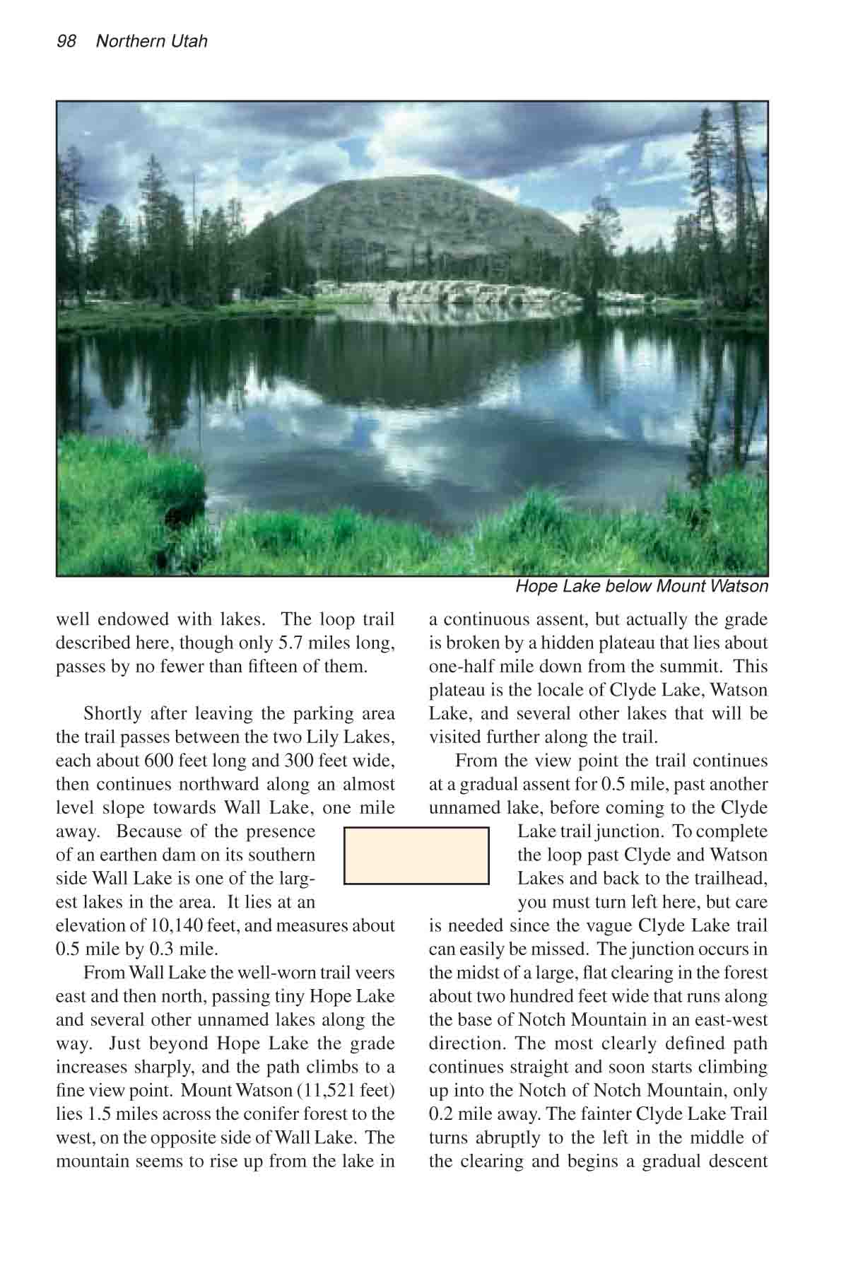
and the path climbs to a fine view point. Mount Watson (11,521
feet) lies 1.5 miles across the conifer forest to the west, on
the opposite side of Wall Lake. The mountain seems to rise up
from the lake in a continuous assent, but actually the grade
is broken by a hidden plateau that lies about one-half mile down
from the summit. This plateau is the locale of Clyde Lake, Watson
Lake, and several other lakes that will be visited further along
the trail.
From the view point the trail continues
at a gradual assent for 0.5 miles, past another unnamed lake,
before coming to the Clyde Lake trail junction. To complete the
loop past Clyde and Watson Lakes and back to the trailhead, you
must turn left here, but care is needed since the vague Clyde
Lake trail can easily be missed. The junction occurs in the midst
of a large, flat clearing in the forest about two hundred feet
wide that runs along the base of Notch Mountain in an east-west
direction. The most clearly defined path continues straight and
soon starts climbing up into the notch of Notch Mountain, only
0.2 miles away. The fainter Clyde Lake Trail turns abruptly to
the left in the middle of the clearing and begins a gradual descent
to Twin Lakes, 0.1 mile away. If you have difficulty following
the trail, don’t worry, it gets better. Just walk due east
along the base of Notch Mountain, neither climbing nor descending,
and you should run right into the Twin Lakes.
The larger Twin Lake is about 500
feet in diameter, with the smaller Twin on the southern side
about half that size. Although there is only a thin stretch of
land between the two, the larger lake cannot be seen from its
smaller twin, so if you run into the smaller lake first, turn
north to find the larger one. The trail, more distinct now, runs
around the northern shore of the larger Twin Lake. After leaving
Twin Lakes the trail continues in a westerly direction for 0.2
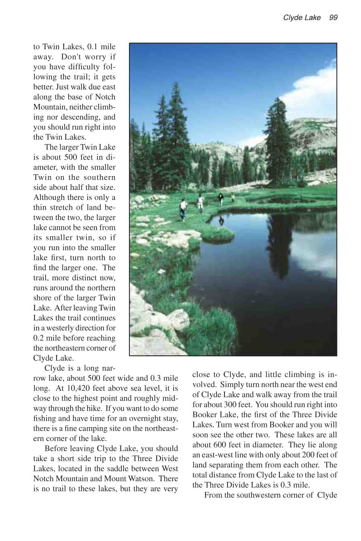
mile before reaching the northeastern corner of Clyde Lake. Clyde
is a long, narrow lake-about 500 feet wide and 0.3 mile long.
At 10,420 feet above sea level, it is the highest lake on the
loop, and it lies roughly midway through the hike. If you want
to do some fishing and have time for an overnight stay, there
is a fine camping site on the northeastern corner of the lake.
Before leaving Clyde Lake, you
should take a short side trip to the Three Divide Lakes, located
in the saddle between West Notch Mountain and Mount Watson. There
is no trail to these lakes, but they are very close to Clyde,
and little climbing is involved. Simply turn north near the west
end of Clyde Lake and walk away from the trail for about 300
feet. You should run right into Booker Lake, the first of the
Three Divide Lakes. Turn west from Booker and you will soon run
into the other two. These lakes are all about 600 feet in diameter.
They lie along an east-west line with only about 200 feet of
land separating them from each other. The total distance from
Clyde Lake to the last of the Three Divide Lakes is about 0.3
mile.
From the southwestern corner of
Clyde Lake the trail turns southward along the base of Mount
Watson to reach Watson Lake, 0.4 mile away. Watson Lake, which
is about 500 feet in diameter, is the first of several small
lakes that lie like a string of beads along the downhill path
leading back to the Crystal Lake Trailhead. The path passes by
Watson Lake, tiny Linear Lake, slightly larger Petit Lake, and
finally Cliff Lake, all within a half mile of each other. Cliff
Lake, about twice the size of Watson, is, in my opinion, the
prettiest of the four. The route passes along the eastern shores
of these lakes, so hikers coming down from Clyde Lake should
bear to the left.
After leaving the southern corner
of Cliff Lake the trail heads south into the woods again, loosing
240 feet of elevation and arriving at West Lily Lake after 0.2
mile. Here the path intersects the Crystal Lake Trail, and in
order to return to the parking area you must turn left. If you
are in the mood for one more lake, however, Crystal Lake is just
a five minute walk to the right from the junction.
The Notch and Meadow Lake
As mentioned earlier, the Notch
of Notch Mountain is only 0.2 mile from the point where Clyde
Lake Trail branches off the main trail. Before making the turn
to Clyde Lake, some hikers may want to climb into the notch.
At an elevation of 10,580 feet, the Notch is only 120 feet higher
than the trail junction, and the view is well worth the climb.
If you drop down on the other side of the Notch for another 0.2
mile you will come to Lovenia Lake, about 300 feet across, and
beyond Lovenia the route passes Ibantic and Meadow Lakes. Meadow
Lake, nearly as big as Wall Lake, is 2.1 miles from the Notch. |