|
Links to other sites:
Ordering books & Maps
Comments about this site or our book:

|
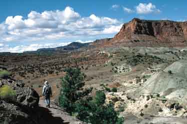
Chimney Rock Canyon is a long,
narrow desert drainage on the northwestern side of Capital Reef
National Park. It begins just outside the park on the eastern
slopes of Thousand Lakes Mountain and meanders for some 15 miles
through the Waterpocket Fold before draining into the Fremont
River. This hike intersects the canyon at its midpoint and follows
it for its last six miles.
The hike is particularly interesting
from a geological point of view because it passes through so
many different geologic strata. The route begins in the Moenkopi
Formation, then passes through the Shinarump, Chinle, Wingate,
and Kayenta Formations, and finally ends in the center of the
Waterpocket Fold at the base of the Navajo Sandstone. The sequence
is unusual because the Navajo Sandstone was deposited about forty
million years after the Moenkopi Formation, yet here it lies
a thousand feet lower.
As you descend through the canyon
you will see successive layers of younger rock slanting downward
along the walls to meet the older layers at the bottom. The Waterpocket
Fold is a giant wrinkle in the earths crust that was formed in
southern Utah about 65 million years ago. Because of the uplifting
and subsequent erosion along the Fold, the exposed rock is now
older on the west side than the east. The streambed of Chimney
Rock Canyon cuts into the Waterpocket Fold from its western side
and ends near its midpoint.
Chimney Rock Canyon was named
after Chimney Rock, an impressive pinnacle of Moenkopi Shale
that rises from the desert floor near the trailhead. The trail
begins by winding gently upward from the parking area on the
west side of Chimney Rock and then around to its north side.
After walking 0.5 mile and climbing 250 feet you will come to
a junction where another trail takes off to the right. This alternative
route veers south again to pass by the base of Chimney Rock and
then rejoins the main trail 1.7 miles later. If you have the
time you might want take this detour for a closer look at the
monolith, but doing so will add about a mile to the total length
of the hike. If you take the shorter route, to the left, you
will reach the point where the two trails come together again
after about 20 minutes.
After the second junction the trail
descends gradually down a short, unnamed canyon for about 1.6
miles before finally intersecting Chimney Rock Canyon. To reach
the Fremont River you must turn right when you reach the main
canyon, but if time permits, or if you are doing this hike as
an overnighter, you may want to make a side trip to the canyon’s
best known spring. The spring lies about 1.0 mile upcanyon to
the left. It is situated in an alcove just above a small pool
of water under the north wall of the canyon. You will know you
are near when you see a grove of large cottonwood trees. (Cottonwood
trees in the desert country of southern Utah usually mark the
presence of water.) Chimney Rock Canyon is often called Spring
Canyon, because of this spring.
From the point where the trail
first meets Chimney Rock Canyon it is 6.9 miles to the Fremont
River. There is no real trail, but the route is generally easy
to walk. You will be following the sandy creek bed nearly all
the way. There are some deer tracks in the canyon bottom, but
the most interesting aspect of the hike is the geology. Much
of the rock is a deep red color, and in the section of the canyon
that passes through the Wingate Formation, the sandstone walls
are sheer and smooth. You may be surprised to find frequent boulders
of black volcanic rock. These worn boulders were washed downstream
by flash floods from a volcanic area near the source of the canyon.
Now they lie in stark contrast to the reddish sandstone and shale
of the Waterpocket Fold.
About half way through the gorge
you will enter a half-mile section of narrows, where the canyon
walls converge to a mere five feet apart. There are also two
ten-foot pouroffs, or dry falls, in the bottom of this stretch
of canyon. These falls are relatively easy to climb down and
should not be a problem unless you are carrying a large backpack.
But if they do present a problem, there is an alternative route
around them. When you come to the first pouroff retrace your
footsteps a few hundred feet back to a point where you can climb
up to the ledge on the north side of the narrows. There you will
find a primitive path that bypasses the obstacles before dropping
back to the canyon bottom.
Finally, just before you reach the end
of the hike, the canyon widens and becomes less arid. The walls
change from the ruddy, fissured Wingate and Kayenta Sandstone
to the smooth, white crossbedded texture of the Navajo Sandstone.
Soon you will round the last bend in the canyon and be confronted
with your last obstacle-the Fremont River.
Under normal circumstances, fording
the Fremont is no problem. It is seldom more than 18 inches deep.
If there has been a lot of rain, however, its depth can easily
rise to twice that. Find a stout stick to help you with the crossing.
Walk slowly, taking small steps, and make sure the stick and
one foot are firmly planted before moving your other foot. The
stick should be positioned on your downstream side, with your
right side facing upstream as you walk. |