|
Links to other sites:
Ordering books & Maps
Comments about this site or our book:

|
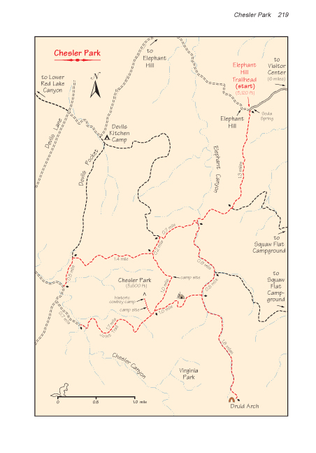
If you can stand the high desert
temperatures, the Needles District of Canyonlands is a hiker's
paradise. The needles themselves are the main attraction. Carved
by the wind and the rain from the multicolored Cedar Mesa Sandstone,
they present a startling array of spires and pinnacles that rise
from the slickrock like a forest of sandstone trees. Some parts
of the trail wind torturously through the stone towers and canyons,
forcing hikers to negotiate one obstacle after another.
Deep inside the rugged needles
country lies an unexpected refuge of gentle grassland. This is
Chesler Park-a flat, circular-shaped meadow about a mile in diameter,
almost completely surrounded by the sandstone needles. There
are three designated camping areas on the perimeter of the meadow,
and one could hardly ask for a more beautiful place to spend
a night or two. There are also several other interesting things
to see within an easy walk of Chesler Park, including an impressive
natural arch and a small Anasazi Indian ruin. The one drawback
that prevents Chesler from being a perfect hiking destination
is the unavailability of water. The nearest reliable spring is
two miles away in Elephant Canyon, so you will have to carry
most of your water with you.
Day 1
The route from Elephant Hill Trailhead
to Chesler Park is only about 3.3 miles long, depending on which
camp site you use. The trail is almost entirely across slickrock,
marked by stone cairns. There is a great deal of up and down,
and this makes the distance seem greater than it actually is.
There are three junctions with intersecting trails along the
way, but the route is clearly marked with signs at each junction
so there shouldn’t be any confusion as to which way to turn.
After 2.8 miles the trail emerges from behind a row of needles
to give you your first view of the northern side of Chesler.
Once you reach Chesler Park you
should decide where you are going to camp so you can shed your
packs. The Park Service allows camping in three places along
the eastern edge of the meadow, but, in my opinion, the southeastern
camp sites have the most to offer. To reach this area continue
south from the last trail junction, along the eastern side of
the park, until you meet another trail coming in from Elephant
Canyon. Turn right here, onto the Joint Trail, and soon you will
pass by the southern side of a rocky island in the center of
the park. The camping area (marked by signs) is along the southwestern
side of the island. The western side of this rock island was
also a popular camping area for cowboys who ran cattle in Chesler
Park from the late 1800s until the early 1960s. You can still
see the remains of their camp just north of the backpackers camping
area.
After you have established a camp
site, leave your backpacks behind and check out the Joint Trail.
Continue walking west from the camping area along the main trail
for about 0.8 mile, where you will find a long, narrow flight
of stone stairs that lead down into a dark, slender crack in
the sandstone. The trail continues through the bottom of the
three-foot crack, called a “joint” by oldtimers, for
some 300 yards before emerging once again at the top of the slickrock.
The Chesler Park hike is full of surprises, but for many the
joint is the most exciting part of the trip.
Soon after emerging from the joint
you will cross the dry streambed of Chesler Canyon and meet a
jeep trail coming down from Elephant Hill. You will have to walk
north along the jeep trail for a short distance to reconnect
with the Chesler Park Trail and complete the loop back to your
camp site. The sides of Chesler Canyon, through which the sandy
road winds, are lined with hundreds of stone needles. Like giant
terrestrial pin cushions, even the hills surrounding the canyon
are packed with clusters of needles. After 0.7 mile on the jeep
road you will see another sign marking the departure of the trail
to Chesler Park. Turn right here and then right again at the
next trail junction. Finally, 1.9 mile from the road you will
again arrive at the northeast corner of Chesler Park.
Day 2
After breaking camp you should
leave Chesler via the southeast exit to Elephant Canyon. About
0.2 mile before you arrive at Elephant Canyon you will have the
opportunity to see an Anasazi Indian ruin. The ruin is a few
hundred feet below the trail, in the bottom of a small canyon
on the north side. You can’t see the ruin from the trail
itself, but just above the site there is a place where previous
hikers have left the main path to walk to a viewpoint only 15
feet away that looks directly down onto it.
There is another trail junction
in the bottom of Elephant Canyon. The northern path leads back
to Elephant Hill where your car is parked. But before going back
you should take off your backpacks and make a side trip to Druid
Arch, 1.8 miles south of the junction at the head of Elephant
Canyon. You will probably see a few scattered water holes in
the creek bed as you make your way up the canyon. This is one
of the few places in the area where you can usually obtain water-a
useful thing to know if you plan to spend more than one night
in Chesler Park.
Druid Arch itself is extremely
impressive. It stands high on the mesa top above Elephant Canyon,
with nothing but blue sky behind it. The appearance of the huge
arch reminds many people of Stonehenge in southern England, hence
its name. (The Druids are the people who built Stonehenge.) In
her book, Desert Quartet, Terry Tempest Williams shares
with us her first impression of Druid Arch:
"Red Rock. Blue sky. This arch is structured metamorphosis.
Once a finlike tower, it has been perforated by a massive cave-in,
responsible now for the keyholes where wind enters and turns.
What has been opened, removed, eroded away, is as compelling
to me as what remains. Druid Arch-inorganic matter-rock rising
from the desert floor as a creation of time, weathered, broken,
and beautiful." (Desert Quartet, Pantheon Books,
New York, 1995)
The best time to see Druid Arch
is in the morning. The trail ends at a magnificent viewpoint
high on the east side of Elephant Canyon where, on most days,
the arch is bathed in the morning sunlight.
From the Chesler Park trail junction,
where you left your backpacks, the trail back to Elephant Hill
continues down the bottom of Elephant Canyon for another 1.4
miles before reaching the trail used on the first day to reach
Chesler Park. From that junction it is another 1.9 miles back
to the Elephant Hill Trailhead.
Alternative Routes
As the map suggests, there are
many alternative routes for this hike. In my opinion it would
be a shame to visit the area without (1) spending at least one
night in Chesler Park, (2) experiencing the Joint Trail, and
(3) seeing Druid Arch; and the route I have suggested will allow
you to do those things with a minimum amount of walking.
If you
have the time, however, I suggest you begin your hike at the
Squaw Flat Campground rather than Elephant Hill, and spend two
nights in Chesler Park (see map on page 211). Doing so will add
2.1 miles to the outbound distance, and 2.7 miles (via Big Spring
Canyon) to the return distance. The section of trail between
Elephant Canyon and Big Spring Canyon is particularly interesting,
with another cave-like crack to walk through and two strategically
placed ladders to negotiate.
|