|
Links to other sites:
Do you have any recent information to add about this trail?
Ordering books & Maps
Comments about this site or our book:

|
Easily accessible from Salt
Lake City, the hike to Amethyst Lake and Basin is probably the
most popular hike into the rugged, north-slope drainages of the
High Uintas. The Uinta Mountains are bisected by a long, winding
spine of Precambrian rock that runs for about a hundred miles
in an east-west direction across northern Utah. The north and
south facing slopes of this ridge are punctuated by a dozen or
so glacier-carved valleys which end abruptly against the quartzite
cliffs of the central spine. It is in the back of one of these
glaciated valleys, the Stillwater Drainage, that Amethyst Basin
and Amethyst Lake, are located. There are several other alpine
lakes within the Stillwater Drainage, but Amethyst Lake is the
largest.
Day 1
For the first two miles the trail
to Amethyst Lake meanders along the east side of Christmas Meadows,
a pleasant, open grassland surrounding Stillwater Creek. This
is a popular fishing area, and there are usually a few fly fishermen
along the creek. The meadow is also favored by grazing animals,
and it is not uncommon to see deer and moose grazing nearby.
So many people visit Christmas Meadows now that in the last 20
years the moose have become almost tame.
Shortly after leaving Christmas
Meadows you will encounter a forest service sign informing you
that you are entering the High Uintas Wilderness Area, and five
minutes later the trail forks. A smaller sign has been nailed
to a tree at the fork instructing hikers that they should take
the left fork, leading away from Stillwater Creek, to reach Amethyst
Lake.
Soon after leaving Stillwater Creek
the trail abruptly becomes much steeper, gaining 600 feet in
the first half mile. The route is also very rocky here, and hikers
carrying a backpack should take care not to twist an ankle. The
monotony of the tiring climb is broken by several picturesque
cascades along Ostler Creek only a few feet from the trail. After
the first half mile the grade decreases, and the trail settles
down to a more gradual but steady climb upward. Occasionally
the path breaks briefly out of the trees to give hikers fine
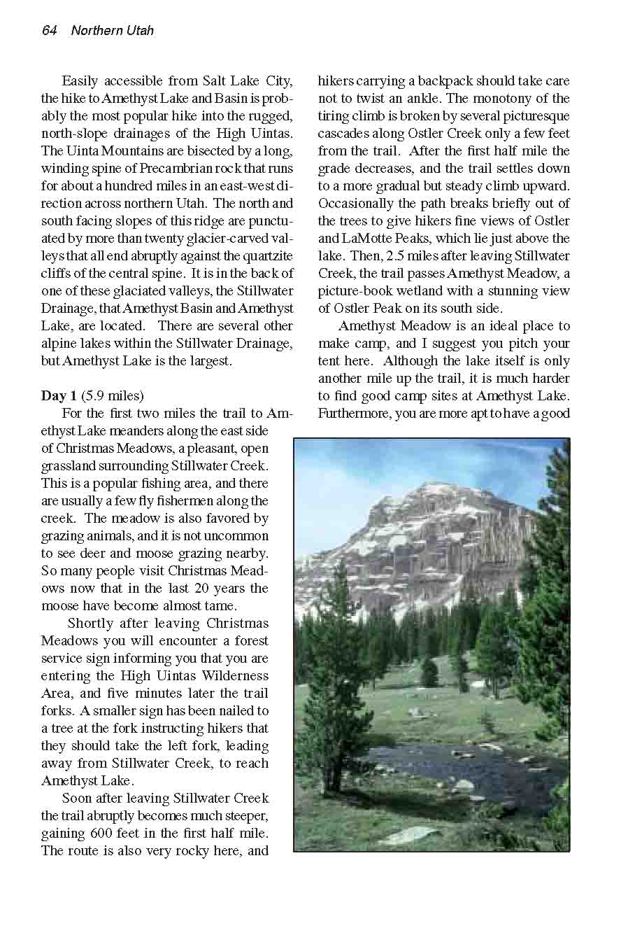
views of Ostler and LaMotte Peaks, which lie just above the lake.
Then, 2.5 miles after leaving Stillwater Creek, the trail passes
Amethyst Meadow, a picture-book wetland with a stunning view
of Ostler Peak on its south side.
Amethyst Meadow is an ideal place
to make camp, and I suggest you pitch your tent here. Although
the lake itself is only another mile up the trail, it is much
harder to find good camp sites at Amethyst Lake. You are more
apt to have a good night’s sleep at the meadow, which is
400 feet lower and better protected than the lake. In consideration
of others, however, please pitch your tent at least a few hundred
feet from the trail and away from the water.
You will probably have a little
time left for some afternoon exploring after you have selected
a camp site and taken off your packs. I suggest you save Amethyst
Lake for the morning and check out Ostler Lake. If you have your
camera along you can get a magnificent picture of Ostler Peak
from across Ostler Lake in the late afternoon sun.
At the edge of Amethyst Meadow,
just beyond the point where the trail crosses Ostler Creek, you
will see a sign that says “Ostler Lake, 1/2 mile”.
Unfortunately there is no reliable trail to Ostler Lake, but
it isn’t too hard to find if you have a compass. From the
sign, head straight into the woods along a compass bearing of
about 240 degrees (slightly south of magnetic west). After walking
about 0.4 mile and gaining about 240 feet of elevation you will
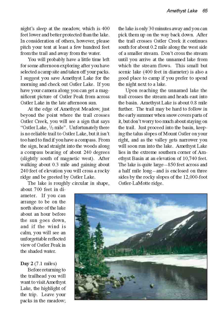
cross a rocky ridge and be greeted by Ostler Lake. The lake is
roughly circular in shape, about 700 feet in diameter. If you
can arrange to be on the east shore of the lake about an hour
before the sun goes down, and if the wind is calm, you will see
an unforgettable reflected view of Ostler Peak in the shaded
water.
Day 2
After breaking camp, you will want
to visit Amethyst Lake, the highlight of the trip. Leave your
packs in the meadow-the lake is only 30 minutes away, and you
can pick them up on the way back down. After the trail crosses
Ostler Creek it continues south for about 0.2 mile along the
west side of a smaller stream. Don’t cross the stream until
you arrive at the unnamed lake from which the stream flows. This
small but scenic lake (400 feet in diameter) is also a good place
to camp if you prefer to spend the night next to a lake. Upon
reaching the unnamed lake the trail crosses the stream and heads
east into the basin. Amethyst Lake is about 0.8 mile further.
The trail may be hard to follow in the early summer when snow
covers parts of it, but don’t worry too much about staying
on the trail. Just proceed into the basin, keeping the talus
slopes of Mount Ostler on your right, and as the valley gets
narrower you will soon run into the lake. Amethyst Lake lies
in the extreme southern corner of Amethyst Basin, at an elevation
of 10,740 feet. The lake is quite large-850 feet across and a
half mile long-and is enclosed on three sides by the rocky slopes
of the 12,000-feet-high Ostler-LaMotte ridge. |